Back Бомі Byelorussian Бомі BE-X-OLD Боми Bulgarian Bomi Breton Bomi Catalan Bomi County CEB Bomi County German Condado de Bomi Spanish Bomi maakond Estonian Bomi Basque
Bomi County | |
|---|---|
 Bomi Lake | |
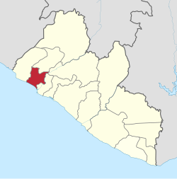
 Location in Liberia | |
| Coordinates: 6°45′N 10°45′W / 6.750°N 10.750°W | |
| Country | |
| Capital | Tubmanburg |
| Districts | Dewoin District Klay District Senjeh District Seuhn Mecca District |
| Established | 1984 |
| Government | |
| • Superintendent | Haja Washington |
| Area | |
| • Total | 1,932 km2 (746 sq mi) |
| Population (2022) | |
| • Total | 133,668 |
| • Density | 44/km2 (113/sq mi) |
| Time zone | UTC+0 (GMT) |
| ISO 3166 code | LR-BM |
| HDI (2018) | 0.427[1] low · 6th of 15 |
Bomi is a county in the northwestern portion of the West African nation of Liberia. The county was established in 1984. The county's area is 746 square miles (1,900 km2).
Bomi is one of 15 counties that comprise the first-level of administrative division in the nation. Tubmanburg serves as the county's capital. The County has four administrative districts.
Bomi is bordered on the northwest by Grand Cape Mount County, on the northeast by Gbarpolu and Bong Counties, on the southeast by Montserrado County and on the southwest by the Atlantic Ocean. As of the 2022 Liberian census, Bomi had a population of 133,668, making it the nation's eleventh most populous county.[2]
- ^ "Sub-national HDI - Area Database - Global Data Lab". hdi.globaldatalab.org. Retrieved 13 September 2018.
- ^ "Liberia: Counties, Major Cities, Towns & Urban Areas - Population Statistics, Maps, Charts, Weather and Web Information". www.citypopulation.de. Retrieved 16 January 2024.
© MMXXIII Rich X Search. We shall prevail. All rights reserved. Rich X Search
