Back بونینقتون AZB Bonnington CEB Bonnington Welsh Bonnington Spanish بونینگتون Persian Bonnington French Bonnington (Kent) Italian Bonnington LLD Bonnington Dutch Bonnington Polish
| Bonnington | |
|---|---|
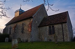
 St Rumwold's Church, a Grade I listed church | |
Location within Kent | |
| Population | 109 (2001)[1] |
| OS grid reference | TR057352 |
| Civil parish |
|
| District | |
| Shire county | |
| Region | |
| Country | England |
| Sovereign state | United Kingdom |
| Post town | TONBRIDGE |
| Postcode district | TN25 |
| Dialling code | 01233 |
| Police | Kent |
| Fire | Kent |
| Ambulance | South East Coast |
| UK Parliament | |
Bonnington is a dispersed village and civil parish on the northern edge of the Romney Marsh in Ashford District of Kent, England. The village is located eight miles (13 km) to the south of the town of Ashford on the B2067 (Hamstreet to Hythe road).
Bonnington has under 100 inhabitants and has historic connections with smuggling. The parish used to boast its own school at the T-junction with the former B2069, and a public house (The Oak) located nearly two miles southeast of the village. The parish church, dedicated to St Rumwold, the child saint,[2] is about half a mile to the south of the hamlet, on the Royal Military Canal.
The parish council is now linked with the larger village of Aldington (where the population is now included) which is where the nearest shops can be found.
- ^ Ashford Borough Council Archived 15 November 2010 at the Wayback Machine Census 2001
- ^ Romney Deanery Archived 27 July 2007 at the Wayback Machine
© MMXXIII Rich X Search. We shall prevail. All rights reserved. Rich X Search
