Back Rugby District CEB Bwrdeistref Rugby Welsh Borough of Rugby German Municipio de Rugby Spanish Rugby (borough) French Rugby (borough) Italian 럭비구 Korean Rugby (district) Dutch Rugby (distrikt) NB Rugby (borough) Polish
Borough of Rugby | |
|---|---|
 Rugby, the largest settlement and administrative centre of the borough | |
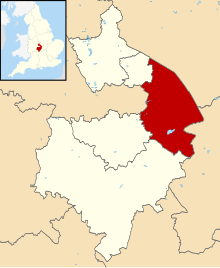
 Shown within Warwickshire | |
| Sovereign state | United Kingdom |
| Constituent country | England |
| Region | West Midlands |
| Administrative county | Warwickshire |
| Admin. HQ | Rugby |
| Government | |
| • Type | Non-metropolitan borough |
| • MPs: | Mark Pawsey (Rugby) Jeremy Wright (Kenilworth and Southam) |
| Area | |
| • Total | 136 sq mi (351 km2) |
| • Rank | 101st |
| Population (2022) | |
| • Total | 116,436 |
| • Rank | Ranked 208th |
| • Density | 860/sq mi (330/km2) |
| Ethnicity (2021) | |
| • Ethnic groups | |
| Religion (2021) | |
| • Religion | List
|
| Time zone | UTC+0 (Greenwich Mean Time) |
| • Summer (DST) | UTC+1 (British Summer Time) |
| ONS code | 44UD (ONS) E07000220 (GSS) |
The Borough of Rugby is a local government district with borough status in Warwickshire, England. The borough comprises the town of Rugby where the council has its headquarters, and the rural areas surrounding the town. At the 2021 census the borough had a population of 114,400, of which 78,125 lived in the built-up area of Rugby itself and the remainder were in the surrounding areas.
Aside from Rugby itself, more notable settlements include Binley Woods, Brinklow. Dunchurch, Long Lawford, Monks Kirby, Wolston, Wolvey and the new large development of Houlton. It includes a large area of the West Midlands Green Belt in the mostly rural area between Rugby and Coventry.
Between 2011 and 2021, the population of Rugby borough saw a 14.3% increase in population from around 100,100 in to 114,400, meaning it has had the largest percentage increase of any local authority area in the West Midlands region since 2011.[2]
The borough extends from Coventry in the west to the borders with Leicestershire and Northamptonshire in the east, it borders the Warwickshire districts of Nuneaton and Bedworth to the north-west, Stratford-on-Avon to the south, and Warwick to the south-west. The Leicestershire districts of Hinckley and Bosworth, Blaby and Harborough are bordered to the north and north-east, whilst West Northamptonshire is bordered to the south-east.
- ^ a b UK Census (2021). "2021 Census Area Profile – Rugby Local Authority (E07000220)". Nomis. Office for National Statistics. Retrieved 5 January 2024.
- ^ "How the population changed in Rugby: Census 2021". Office for National Statistics. Retrieved 10 November 2022.
© MMXXIII Rich X Search. We shall prevail. All rights reserved. Rich X Search