Back Grenzstein ALS Mollón AN حجر حد (أرفة) Arabic Moastoa BAR Fita de frontera Catalan Hraniční kámen Czech Grænsesten Danish Grenzstein German Limŝtono Esperanto Hito fronterizo Spanish


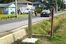
A boundary marker, border marker, boundary stone, or border stone is a robust physical marker that identifies the start of a land boundary or the change in a boundary, especially a change in direction of a boundary.[1] There are several other types of named border markers, known as boundary trees,[2][3] pillars, monuments, obelisks, and corners.[1] Border markers can also be markers through which a border line runs in a straight line to determine that border.[1] They can also be the markers from which a border marker has been fixed.[1]
- ^ a b c d Porter, John (June 1990). AN HISTORICAL PERSPECTIVE – Longitude 129 degrees east, and why it is not the longest, straight line in the world. National Perspectives – 32nd Australian Surveyors Congress Technical Papers 31 March – 6 April 1990. Canberra: The Institution: Eyepiece – Official Organ of The Institution of Surveyors, Australia, W.A. Division. pp. 18–24.
- ^ Tarkiainen, Ü (2012). "Trees for marking boundaries of landed property in premodern Estonia". Estonian Journal of Ecology. 61 (1): 53. doi:10.3176/eco.2012.1.06.
- ^ Blomley, Nicholas (28 January 2016). "The Boundaries of Property: Complexity, Relationality, and Spatiality: The Boundaries of Property". Law & Society Review. 50 (1): 224–255. doi:10.1111/lasr.12182.
© MMXXIII Rich X Search. We shall prevail. All rights reserved. Rich X Search