Back برادلی استوک AZB Bradley Stoke CEB Bradley Stoke Welsh برادلی استوک Persian Bradley Stoke French Bradley Stoke Irish Bradley Stoke Italian Bradley Stoke LLD Bradley Stoke Dutch Bradley Stoke NN
| Bradley Stoke | |
|---|---|
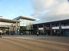
 Willow Brook Centre, the town centre | |
Location within Gloucestershire | |
| Population | 20,690 (2021 Census)[1] |
| OS grid reference | ST621813 |
| Unitary authority | |
| Ceremonial county | |
| Region | |
| Country | England |
| Sovereign state | United Kingdom |
| Post town | BRISTOL |
| Postcode district | BS32 |
| Dialling code | 0117 and 01454 |
| Police | Avon and Somerset |
| Fire | Avon |
| Ambulance | South Western |
| UK Parliament | |
Bradley Stoke is a town in South Gloucestershire, England, situated 6 miles (10 kilometres) north-northeast of Bristol city centre.[2] The town is the northernmost part of the Bristol built-up area.[3]
Planned in the 1970s, building works began in 1987. Bradley Stoke was Europe's largest new town built with private investment. It is named after two local streams, the Bradley Brook and Stoke Brook.
Bradley Stoke is part of the North Fringe of Bristol, an extensive area of housing and employment developed during the late 20th and early 21st centuries.[4] It is bordered by Patchway to the west and Stoke Gifford to the south, but unlike these neighbours, Bradley Stoke has fewer major employers and is primarily a residential suburb, being 40% detached housing.[3] The M5 and M4 motorways form its northern and eastern boundaries, beyond which is the Avon Green Belt.[3]
- ^ "Bradley Stoke". City population. Retrieved 25 October 2022.
- ^ OS Explorer Map, Bristol and Bath, Keynsham & Marshfield. Scale: 1:25 000.Publisher: Ordnance Survey B4 edition (2013). ISBN 978 0319239773
- ^ a b c "South Gloucestershire Core Strategy - Community Profiles" (PDF). South Gloucestershire Council. Retrieved 30 April 2024.
- ^ "South Gloucestershire Suburban Continuation Study". Nash Partnership.
© MMXXIII Rich X Search. We shall prevail. All rights reserved. Rich X Search
