Back نهر برانتس Arabic نهر برانتس ARZ Kali Brantas (suba sa Jawa Timur, lat -7,46, long 112,43) CEB Brantas (ibaia) Basque Brantas French Sungai Brantas ID Brantas Italian ブランタス川 Japanese Kali Brantas JV Sungai Brantas Malay
| Brantas River Kali Brantas, Sungai Brantas | |
|---|---|
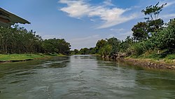
 Brantas river, Kediri regency. | |
| Location | |
| Country | |
| Province | East Java |
| Physical characteristics | |
| Source | Arjuno-Welirang |
| Mouth | |
• location | Madura Strait |
| Length | 320 km (200 mi) |
| Basin size | 11,900 km2 (4,600 sq mi)[1] |
| Discharge | |
| • location | Near mouth |
| • average | 579 m3/s (20,400 cu ft/s) |
| Basin features | |
| River system | Brantas Basin (DAS220228)[1] |


The Brantas is the longest river in East Java, Indonesia.[2] It has a length of 320 km,[3] and drains an area of over 11,000 km2 from the southern slope of Mount Kawi-Kelud-Butak, Mount Wilis, and the northern slopes of Mount Liman-Limas, Mount Welirang, and Mount Anjasmoro.[4] Its course is semi-circular or spiral in shape: at its source, the river heads southeast, but gradually curves south, then southwest, west, then north, and finally it flows generally eastward at the point where it branches off to become the Kalimas and Porong River.
- ^ a b https://hukumonline.com/pusatdata/detail/lt4f2f760d2fff3/keputusan-menteri-kehutanan-nomor-sk511menhutv2011-tahun-2011
- ^ Kali Brantas at Geonames.org (cc-by); Last updated 2013-06-04; Database dump downloaded 2015-11-27
- ^ Ramu, Kikkeri (December 2004). "Brantas River Basin Case Study, Indonesia" (PDF). Background Paper. Worldbank. p. 36.
- ^ Whitten, T; Soeriaatmadja, R. E.; Suraya A. A. (1996). The Ecology of Java and Bali. Hong Kong: Periplus Editions Ltd. p. 132.
© MMXXIII Rich X Search. We shall prevail. All rights reserved. Rich X Search

