Back مقاطعة بريستول (رود آيلاند) Arabic Bristol County, Rhode Island BAR Бристъл (окръг, Роуд Айланд) Bulgarian ব্রিস্টল কাউন্টি, রোড আইল্যান্ড BPY Bristol Gông (Rhode Island) CDO Бристоль (гуо, Род-Айленд) CE Bristol County (kondado sa Tinipong Bansa, Rhode Island) CEB Bristol County, Rhode Island Welsh Bristol County (Rhode Island) German Kantono Bristol (Rod-Insulo) Esperanto
Bristol County | |
|---|---|
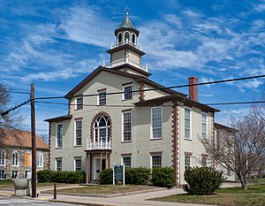
 Bristol County Courthouse in Bristol | |
 Location within the U.S. state of Rhode Island | |
 Rhode Island's location within the U.S. | |
| Coordinates: 41°42′N 71°17′W / 41.70°N 71.28°W | |
| Country | |
| State | |
| Founded | 1747 |
| Named for | Bristol, England |
| Seat | Bristol |
| Largest town | Bristol |
| Area | |
| • Total | 45 sq mi (120 km2) |
| • Land | 24 sq mi (60 km2) |
| • Water | 21 sq mi (50 km2) 46% |
| Population (2020) | |
| • Total | 50,793 |
| • Density | 1,128.7/sq mi (435.8/km2) |
| Time zone | UTC−5 (Eastern) |
| • Summer (DST) | UTC−4 (EDT) |
| Congressional district | 1st |
Bristol County is a county located in the U.S. state of Rhode Island. As of the 2020 census, the population was 50,793,[1] making it the least populous county in Rhode Island. In terms of land area, it is the third-smallest county in the United States, at only 25 square miles (65 km2). The county was created in 1747 when it was separated from Bristol County, Massachusetts.[2] Bristol County is included in the Providence-Warwick, RI-MA Metropolitan Statistical Area, which in turn constitutes a portion of the greater Boston-Worcester-Providence, MA-RI-NH-CT Combined Statistical Area.
- ^ "Census - Geography Profile: Bristol County, Rhode Island". United States Census Bureau. Retrieved November 20, 2021.
- ^ "Rhode Island: Individual County Chronologies". Pennsylvania Atlas of Historical County Boundaries. The Newberry Library. 2009. Archived from the original on July 25, 2015. Retrieved March 14, 2015.
© MMXXIII Rich X Search. We shall prevail. All rights reserved. Rich X Search