Back Burgenland Afrikaans Burgenland ALS Burgenland AN بورغنلاند Arabic Burgenland AST Burgnland BAR Бургенланд Byelorussian Бургенлянд BE-X-OLD Бургенланд Bulgarian বুর্গেনলান্ড Bengali/Bangla
This article needs additional citations for verification. (February 2025) |
Burgenland | |
|---|---|
| Anthem: "Mein Heimatvolk, mein Heimatland" | |
 | |
| Country | |
| Capital | Eisenstadt |
| Government | |
| • Body | Landtag Burgenland |
| • Governor | Hans Peter Doskozil (SPÖ) |
| Area | |
• Total | 3,680 km2 (1,420 sq mi) |
| Population (2023) | |
• Total | 301,250 |
| • Density | 82/km2 (210/sq mi) |
| GDP | |
| • Total | €9.498 billion (2021) |
| • Per capita | €32,000 (2021) |
| Time zone | UTC+1 (CET) |
| • Summer (DST) | UTC+2 (CEST) |
| ISO 3166 code | AT-1 |
| HDI (2022) | 0.890[2] very high · 9th of 9 |
| NUTS Region | AT1 |
| Votes in Bundesrat | 3 (of 62) |
| Website | www |
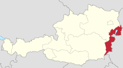
Burgenland (Austrian German pronunciation: [ˈbʊrɡn̩land] ⓘ; Hungarian: Őrvidék; Croatian: Gradišće; Austro-Bavarian: Burgnland; Slovene: Gradiščanska; Slovak: Hradsko) is the easternmost and least populous state of Austria. It consists of two statutory cities and seven rural districts, with a total of 171 municipalities. It is 166 km (103 mi) long from north to south but much narrower from west to east (5 km or 3 mi wide at Sieggraben). The region is part of the Centrope Project. The name of Burgenland was invented/coined in 1922, after its territories became part of Austria. The population of Burgenland as of 1 January 2024 is 301,951. Burgenland's capital is Eisenstadt.[3]
- ^ "Basisdaten Bundesländer" (PDF). Archived (PDF) from the original on 2006-10-09. Retrieved 2023-09-01.
- ^ "Sub-national HDI – Area Database – Global Data Lab". hdi.globaldatalab.org. Retrieved 2018-09-13.
- ^ "Archived copy" (PDF). Archived from the original on April 10, 2023. Retrieved July 30, 2023.
{{cite web}}: CS1 maint: archived copy as title (link) CS1 maint: bot: original URL status unknown (link)
© MMXXIII Rich X Search. We shall prevail. All rights reserved. Rich X Search

