Back خليج بايرون Arabic خليج بايرون ARZ Byron Bay Catalan Byron Bay (lungsod) CEB Byron Bay German Byron Bay Spanish خلیج بایرون، نیو ساوت ولز Persian Byron Bay French Byron Bay Irish ביירון ביי HE
| Byron Bay Cavvanbah (Minjungbal) New South Wales | |||||||||
|---|---|---|---|---|---|---|---|---|---|
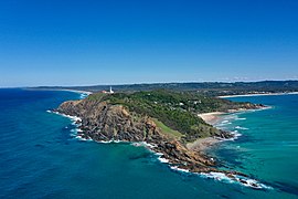
 Byron Bay, NSW (aerial shot showing Byron Bay's lighthouse, beaches and hinterland) | |||||||||
| Coordinates | 28°38′35″S 153°36′54″E / 28.64306°S 153.61500°E | ||||||||
| Population | 6,330 (2021 census)[1] | ||||||||
| Postcode(s) | 2481 | ||||||||
| Elevation | 3 m (10 ft) | ||||||||
| Location |
| ||||||||
| LGA(s) | Byron Shire | ||||||||
| County | Rous | ||||||||
| State electorate(s) | Ballina | ||||||||
| Federal division(s) | Richmond | ||||||||
| |||||||||


Byron Bay (Minjungbal: Cavvanbah) is a beachside town located in the far-northeastern corner of New South Wales, Australia (in Bundjalung Country). It is located 772 kilometres (480 mi) north of Sydney and 165 kilometres (103 mi) south of Brisbane. Cape Byron, a headland adjacent to the town, is the easternmost point of mainland Australia.[2] At the 2021 census, the town had a permanent population of 6,330.[1] It is the largest town of Byron Shire local government area, though not the shire's administrative centre (which is Mullumbimby).
- ^ a b Australian Bureau of Statistics (28 June 2022). "Byron Bay". 2021 Census QuickStats. Retrieved 20 August 2022.
 Material was copied from this source, which is available under a Creative Commons Attribution 4.0 International License Archived 16 October 2017 at the Wayback Machine.
- ^ "Most Easterly Point In Mainland Australia | Byron Bay | Australia | AFAR". www.afar.com. 27 May 2015. Retrieved 18 May 2020.
© MMXXIII Rich X Search. We shall prevail. All rights reserved. Rich X Search

