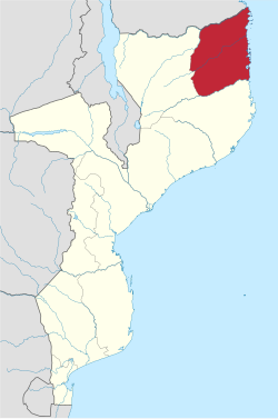
Back Cabo Delgado (provinsie) Afrikaans محافظة كابو ديلغادو Arabic MozambikaCaboDelgadoWinka AVK Кабу-Дэлгаду BE-X-OLD Кабо Делгадо Bulgarian Cabo Delgado Catalan Cabo Delgado Province CEB Cabo Delgado (provins) Danish Provinz Cabo Delgado German Κάμπο Ντελγκάντο Greek
Cabo Delgado
Jimbo la Kabo Delgado (Swahili) | |
|---|---|
 | |
 Cabo Delgado, Province of Mozambique | |
| Country | Mozambique |
| Capital | Pemba |
| Government | |
| • Governor | Valige Tauabo |
| Area | |
| • Total | 82,625 km2 (31,902 sq mi) |
| Population (2017) | |
| • Total | 2,320,261 |
| • Density | 28/km2 (73/sq mi) |
| Postal code | 32xxx |
| Area code | (+258) 278 |
| HDI (2019) | 0.391[1] low · 11th of 11 |
| Official language | Portuguese |
| Provincial de facto language | Swahili |
| Website | www |
Cabo Delgado [ˈkaβu ðɛlˈɣaðu] (Swahili: Jimbo wa Kabo Delgado) is the northernmost province of Mozambique. It has an area of 82,625 km2 (31,902 sq mi) and a population of 2,320,261 (2017).[2] As well as bordering Mtwara Region in the neighboring country of Tanzania, it borders the provinces of Nampula and Niassa. The region is an ethnic stronghold of the Makonde tribe, with the Makua and Mwani as leading ethnic minorities.[3]
Pemba is the capital of the province; other important cities include Montepuez and Mocímboa da Praia.
- ^ "Sub-national HDI - Area Database - Global Data Lab". hdi.globaldatalab.org. Retrieved 2018-09-13.
- ^ "Mozambique at GeoHive". Archived from the original on 2014-09-24. Retrieved 2016-02-04.
- ^ Sousa., Santos, Ana Margarida (2011). History, memory and violence : changing patterns of group relationship in Mocimboa da Praia, Mozambique. Oxford University. OCLC 793677658.
{{cite book}}: CS1 maint: multiple names: authors list (link)
© MMXXIII Rich X Search. We shall prevail. All rights reserved. Rich X Search