This article needs additional citations for verification. (April 2017) |
| Cache River | |
|---|---|
 A swamp along the river | |
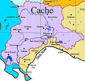
 Cache River Watershed Map | |
| Location | |
| Country | United States |
| State | Illinois |
| Physical characteristics | |
| Source | |
| • location | Anna, Union County, Illinois |
| • coordinates | 37°27′00″N 89°14′44″W / 37.45000°N 89.24556°W |
| Mouth | Ohio River |
• location | South of Mound City, Alexander County, Illinois |
• coordinates | 37°04′01″N 89°10′22″W / 37.06694°N 89.17278°W |
| Length | 92 mi (148 km) |
| Discharge | |
| • location | https://waterdata.usgs.gov/il/nwis/uv/?site_no=03612000&PARAmeter_cd=00065,00060 Forman, IL |
| • average | 312 cu/ft. per sec. |
| Basin features | |
| Protection status | |
| Official name | Cache River and Cypress Creek Wetlands |
| Designated | 1 November 1994 |
| Reference no. | 711[1] |
| Designated | 1972 (Heron Pond); 1980 (Lower Cache) |
The Cache River is a 92-mile-long (148 km)[2] waterway in southernmost Illinois, in a region sometimes called Little Egypt. The basin spans 737 square miles (1,910 km2) and six counties: Alexander, Johnson, Massac, Pope, Pulaski, and Union.[3] Located at the convergence of four major physiographic regions, the river is part of the largest complex of wetlands in Illinois. The Cache River Wetlands is America's northernmost cypress/tupelo swamp and harbors 91 percent of the state's high quality swamp and wetland communities. It provides habitat for more than 100 threatened and endangered species in Illinois. In 1996, the Cache was designated a Wetland of International Importance by the Ramsar Convention.[4]
A significant portion of the Cache River Wetlands are protected by the U.S. Fish and Wildlife Service and the Illinois Department of Natural Resources. Cypress Creek National Wildlife Refuge, established in 1990, covers 15,000 acres (61 km2) of aquatic and riparian habitat, and is eventually planned to expand to 35,500 acres (144 km2). The Illinois Department of Natural Resources' Cache River State Natural Area protects another 14,489 acres (58.63 km2). Local landowners, through Wetlands Reserve Program easements with Natural Resources Conservation Service, protect an additional 13,500 acres (55 km2) of restored wetlands. Also through NRCS, landowners are using a variety of conservation practices, such as conservation tillage, grassed waterways, and reforestation; many of these practices are through NRCS’ Environmental Quality Incentives and Wildlife Habitat Programs. In all, more than 45,000 acres (180 km2) of private lands are using some sort of NRCS conservation program in the Cache River Watershed.
The Lower Cache River, a habitat that encompasses much of these landholdings, has been listed as a U.S. National Natural Landmark. The Heron Pond – Little Black Slough Nature Preserve, another National Natural Landmark, is located within the upper stretch of the Cache, upstream from the Post Creek Cutoff.
- ^ "Cache River and Cypress Creek Wetlands". Ramsar Sites Information Service. Retrieved 25 April 2018.
- ^ U.S. Geological Survey. National Hydrography Dataset high-resolution flowline data. The National Map Archived 2012-03-29 at the Wayback Machine, accessed May 13, 2011
- ^ Demissie, M., Keefer, L., Lian, Y., Yue, F., & Larson, B. (2008). Hydrologic and Hydraulic Modeling and Analyses for the Cache River for the Purposes of Evaluating Current Conditions and Alternative Restoration Measures. Champaign, IL: Center for Watershed Science - Illinois State Water Survey.
- ^ Illinois Department of Natural Resources. "Cache River State Natural Area". Retrieved 19 June 2018.
© MMXXIII Rich X Search. We shall prevail. All rights reserved. Rich X Search
