| Camp Salvation | |
|---|---|
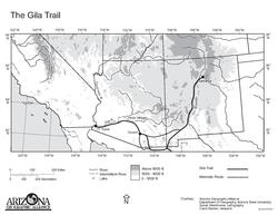 Map of the Gila Trail, the first part of the Southern Emigrant Trail | |
| Location | City Hall of Calexico Calexico, California, US |
| Coordinates | 32°40′12″N 115°29′36″W / 32.670022222°N 115.49324166°W |
| Built | 1849 |
| Demolished | 1849 |
| Official name | Camp Salvation |
| Designated | October 5, 1965 |
| Reference no. | 944[1] |
Camp Salvation was a refugee camp set up on September 23, 1849, to help those traveling to the California Gold Rush. Emigrants were crossing the harsh Sonoran Desert to get to California through the Southern Emigrant Trail. The camp was located in the current town of Calexico, California. Lieutenant Cave Johnson Couts, an Escort Commander with the International Boundary Commission set up the camp. From September 23 till December 1, 1849, the camp helped travelers on the trail. In June 1849 the United States Boundary Commission arrived in San Diego to survey the international border between United States and Mexico.[2]
- ^ "Camp Salvation". Office of Historic Preservation, California State Parks.
- ^ Camp Salvation; First Citizens of Calexico: An Oasis on the Gold Rush Trail, by Ben Franklin Dixon
© MMXXIII Rich X Search. We shall prevail. All rights reserved. Rich X Search