Back Canewdon CEB Canewdon Welsh Canewdon Spanish Canewdon French Canewdon Italian Canewdon Dutch Canewdon Polish Каньюдон Russian Canewdon SIMPLE Canewdon Swedish
| Canewdon | |
|---|---|
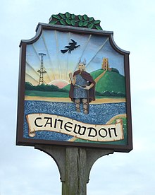
 Canewdon village sign, showing a witch, the church, a Viking, and the former radar tower | |
Location within Essex | |
| Population | 1,072 (2011)[1] |
| OS grid reference | TQ900945 |
| Civil parish |
|
| District | |
| Shire county | |
| Region | |
| Country | England |
| Sovereign state | United Kingdom |
| Post town | ROCHFORD |
| Postcode district | SS4 |
| Dialling code | 01702 |
| Police | Essex |
| Fire | Essex |
| Ambulance | East of England |
| UK Parliament | |
Canewdon is a village and civil parish in the Rochford district of Essex, England. The village is located approximately 4 miles (6.4 km) northeast of the town of Rochford, while the parish extends for several miles on the southern side of the River Crouch.[2][3]
Canewdon is situated on one of the highest hills of the Essex coastline, from which St Nicholas's Church affords wide views of the Crouch estuary.[4] East of the village lies the island of Wallasea, popular for sailing, and a wetland sanctuary for wildlife.[2][3]
The name Canewdon is derived from Old English words meaning 'the hill of Cana's people' and not, as is sometimes claimed, from King Canute, who fought and won the Battle of Ashingdon nearby in 1016 against the English King Edmund Ironside.[2][3]
- ^ "Parish population 2011". Neighbourhood Statistics. Office for National Statistics. Archived from the original on 25 September 2015. Retrieved 23 September 2015.
- ^ a b c "History of Canewdon". Canewdon Parish Council. Retrieved 5 March 2011.
- ^ a b c Smith, J. "Canewdon" (PDF). Rochford District Heritage Guide. Rochford District Council. p. 11. Archived from the original (PDF) on 24 July 2011. Retrieved 6 March 2011.
- ^ "Canewdon Origins and Development". Canewdon Church Conservation Area Appraisal and Management Plan. Rochford District Council. Archived from the original on 16 March 2012. Retrieved 5 March 2011.
© MMXXIII Rich X Search. We shall prevail. All rights reserved. Rich X Search
