Back كنتنهيدة Arabic কান্টানহেডে BPY Cantanhede Catalan Кантаньеди CE Cantanhede (munisipyo sa Portugal, Distrito de Coimbra, lat 40,36, long -8,61) CEB Cantanhede German Cantanhede Esperanto Cantanhede (Portugal) Spanish Cantanhede (Portugal) Basque کانتانیئده Persian
Cantanhede | |
|---|---|
 | |
 | |
| Coordinates: 40°21′N 8°35′W / 40.350°N 8.583°W | |
| Country | |
| Region | Centro |
| Intermunic. comm. | Região de Coimbra |
| District | Coimbra |
| Parishes | 14 |
| Government | |
| • President | João Moura (PSD) |
| Area | |
| • Total | 390.88 km2 (150.92 sq mi) |
| Population (2011) | |
| • Total | 36,595 |
| • Density | 94/km2 (240/sq mi) |
| Time zone | UTC±00:00 (WET) |
| • Summer (DST) | UTC+01:00 (WEST) |
| Website | www.cm-cantanhede.pt |
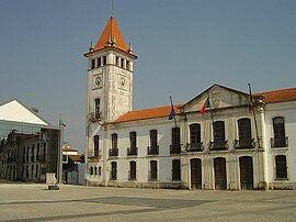
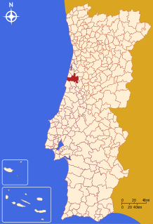
Cantanhede (Portuguese pronunciation: [kɐ̃tɐˈɲeðɨ] ) is a city and municipality in the Coimbra District, in the Centro Region, Portugal. The population in 2011 was 36,595,[1] in an area of 390.88 km2.[2]
- ^ Instituto Nacional de Estatística
- ^ Eurostat Archived October 7, 2012, at the Wayback Machine
© MMXXIII Rich X Search. We shall prevail. All rights reserved. Rich X Search

