Back Kanton Jura Afrikaans Kanton Jura ALS Cantón de Jura AN كانتون جورا Arabic Cantón del Jura AST ژورا (کانتون) AZB Kanton Jura BAN Юра (кантон) Byelorussian Юра (кантон) BE-X-OLD Юра (кантон) Bulgarian
Jura | |
|---|---|
| Republic and Canton of Jura République et canton du Jura (French) | |
| Anthem: La Nouvelle Rauracienne | |
 | |
| Coordinates: 47°22′N 7°9′E / 47.367°N 7.150°E | |
| Capital | Delémont |
| Subdivisions | 64 municipalities, 3 districts |
| Government | |
| • Executive | Gouvernement (5) |
| • Legislative | Parlement (60) |
| Area | |
| • Total | 838.51 km2 (323.75 sq mi) |
| Population (December 2020)[2] | |
| • Total | 73,709 |
| • Density | 88/km2 (230/sq mi) |
| GDP | |
| • Total | CHF 4.687 billion (2020) |
| • Per capita | CHF 63,643 (2020) |
| ISO 3166 code | CH-JU |
| Highest point | 1,302 m (4,272 ft): Mont Raimeux |
| Lowest point | 364 m (1,194 ft): Allaine at Boncourt |
| Joined | 1979 |
| Languages | French |
| Website | www |

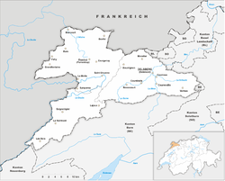
The Republic and Canton of Jura (French: République et canton du Jura), less formally the Canton of Jura or Canton Jura (/ˈ(d)ʒʊərə/ JOOR-ə, ZHOOR-ə, French: [ʒyʁa] ),[needs Arpitan IPA] is the newest (founded in 1979) of the 26 Swiss cantons, located in the northwestern part of Switzerland. The capital is Delémont. It shares borders with the canton of Basel-Landschaft, the canton of Bern, the canton of Neuchatel, the canton of Solothurn, and the French régions of Bourgogne-Franche-Comté and Grand Est.
- ^ Arealstatistik Land Cover - Kantone und Grossregionen nach 6 Hauptbereichen accessed 27 October 2017
- ^ "Ständige und nichtständige Wohnbevölkerung nach institutionellen Gliederungen, Geburtsort und Staatsangehörigkeit". bfs.admin.ch (in German). Swiss Federal Statistical Office - STAT-TAB. 31 December 2020. Retrieved 21 September 2021.
- ^ Statistik, Bundesamt für (2021-01-21). "Bruttoinlandsprodukt (BIP) nach Grossregion und Kanton - 2008-2018 | Tabelle". Bundesamt für Statistik (in German). Retrieved 2023-07-01.
© MMXXIII Rich X Search. We shall prevail. All rights reserved. Rich X Search


