Back Phare du cap Lookout French Faro di capo Lookout Italian Farol do Cabo Lookout Portuguese Маяк мыса Лукаут Russian
 | |
 | |
| Location | Cape Lookout (North Carolina), Carteret County, North Carolina |
|---|---|
| Coordinates | 34°36′19″N 76°32′10″W / 34.60528°N 76.53611°W |
| Tower | |
| Constructed | 1859 |
| Construction | brick |
| Automated | 1950 |
| Height | 163 feet |
| Shape | Conical tower |
| Markings | black, white |
| Heritage | National Register of Historic Places listed place, National Register of Historic Places contributing property |
| Light | |
| First lit | 1859 |
| Focal height | 52 m (171 ft) |
| Lens | third order Fresnel lens |
| Range | 12-19 miles |
| Characteristic | 15-second flash cycle |
Cape Lookout Light Station | |
| Location | On Core Banks, Core Banks, North Carolina |
| Area | 25 acres (10 ha) |
| Built | 1857 |
| NRHP reference No. | 72000097[1] |
| Added to NRHP | October 18, 1972 |
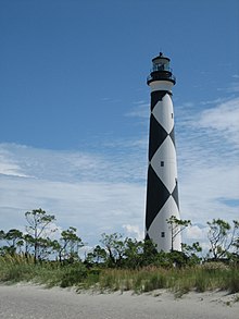
The Cape Lookout Lighthouse is a 163-foot-high lighthouse located on the southern Outer Banks of North Carolina. It flashes every 15 seconds and is visible at least 12 miles out to sea and up to 19 miles. It is one of the very few lighthouses that operate during the day. It became fully automated in 1950.[2] The Cape Lookout Lighthouse is the only such structure in the United States to bear the checkered daymark, intended not only for differentiation between similar light towers, but also to show direction. The center of the black diamonds points in a north-south direction, while the center of the white diamonds points east-west.[3]
- ^ "National Register Information System". National Register of Historic Places. National Park Service. July 9, 2010.
- ^ "Historic Light Station Information and Photography: North Carolina". United States Coast Guard Historian's Office. Archived from the original on 2017-09-23. Retrieved 2008-08-17.
- ^ "Cape Lookout". nps.gov. Retrieved 17 April 2015.
© MMXXIII Rich X Search. We shall prevail. All rights reserved. Rich X Search