Back كابي ماي بوينت (نيوجيرسي) Arabic Cape May Point AST Cape May Point Catalan Кейп-Мей-Пойнт (Нью-Джерси) CE Cape May Point CEB Cape May Point, New Jersey Welsh Cape May Point Spanish Cape May Point (New Jersey) Basque کیپ می پوینت، نیوجرسی Persian Cape May Point French
Cape May Point, New Jersey | |
|---|---|
 | |
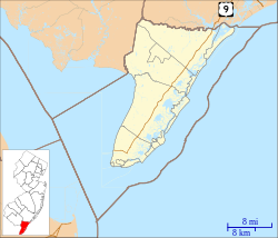
 Location of Cape May Point in Cape May County highlighted in red (left). Inset map: Location of Cape May County in New Jersey highlighted in orange (right). | |
 | |
Location in Cape May County Location in New Jersey | |
| Coordinates: 38°56′13″N 74°57′55″W / 38.936909°N 74.965374°W[1][2] | |
| Country | |
| State | |
| County | |
| Incorporated | April 19, 1878 |
| Named for | Cape May / Cornelius Jacobsen May |
| Government | |
| • Type | Walsh Act |
| • Body | Board of Commissioners |
| • Mayor | Robert J. Moffatt (term ends December 31, 2024)[3][4] |
| • Administrator | Ed Grant[5] |
| • Municipal clerk | Elaine L. Wallace[6] |
| Area | |
| • Total | 0.31 sq mi (0.81 km2) |
| • Land | 0.29 sq mi (0.76 km2) |
| • Water | 0.02 sq mi (0.05 km2) 5.81% |
| • Rank | 553rd of 565 in state 16th of 16 in county[1] |
| Elevation | 7 ft (2 m) |
| Population | |
| • Total | 305 |
| • Estimate (2023)[11] | 299 |
| • Rank | 560th of 565 in state 16th of 16 in county[12] |
| • Density | 1,034.0/sq mi (399.2/km2) |
| • Rank | 380th of 565 in state 7th of 16 in county[12] |
| Time zone | UTC−05:00 (Eastern (EST)) |
| • Summer (DST) | UTC−04:00 (Eastern (EDT)) |
| ZIP Code | |
| Area code(s) | 609 exchanges: 884, 898[15] |
| FIPS code | 3400910330[1][16][17] |
| GNIS feature ID | 0885179[1][18] |
| Website | www |
Cape May Point is a borough located at the tip of the Cape May Peninsula in Cape May County, in the U.S. state of New Jersey. The borough, and all of Cape May County, is part of the Ocean City metropolitan statistical area, and is part of the Philadelphia-Wilmington-Camden, PA-NJ-DE-MD combined statistical area, also known as the Delaware Valley or Philadelphia metropolitan area.[19] As of the 2020 United States census, the borough's population was 305,[10] an increase of 14 (+4.8%) from the 2010 census count of 291,[20][21] which in turn reflected an increase of 50 (+20.7%) from the 241 counted in the 2000 census.[22] The summer population can reach 4,500.[23]
The Cape May Light is located in Lower Township, but is also a point of identity for Cape May Point as it uses the lighthouse as a logo for municipal-owned vehicles. Mayors of the two municipalities previously had a conflict over in which municipality it was located.[24]
Cape May Point is a dry town, one of three municipalities in Cape May County where the sale of alcohol is prohibited by law.[25][26] Cape May Point, Ocean City and Wildwood Crest are Cape May County's only remaining dry municipalities.[27]
- ^ a b c d 2019 Census Gazetteer Files: New Jersey Places Archived March 21, 2021, at the Wayback Machine, United States Census Bureau. Accessed July 1, 2020.
- ^ US Gazetteer files: 2010, 2000, and 1990 Archived August 24, 2019, at the Wayback Machine, United States Census Bureau. Accessed September 4, 2014.
- ^ Cite error: The named reference
Commissionerswas invoked but never defined (see the help page). - ^ 2023 New Jersey Mayors Directory, New Jersey Department of Community Affairs, updated February 8, 2023. Accessed February 10, 2023. As of date accessed, Moffatt is incorrectly listed with a term-end year of 2025.
- ^ Borough Administrator, Borough of Cape May Point. Accessed June 9, 2023.
- ^ Clerk / Registrar, Borough of Cape May Point. Accessed June 9, 2023.
- ^ Cite error: The named reference
DataBookwas invoked but never defined (see the help page). - ^ "ArcGIS REST Services Directory". United States Census Bureau. Retrieved October 11, 2022.
- ^ U.S. Geological Survey Geographic Names Information System: Borough of Cape May Point, Geographic Names Information System. Accessed March 5, 2013.
- ^ a b Cite error: The named reference
LWD2020was invoked but never defined (see the help page). - ^ Cite error: The named reference
PopEstwas invoked but never defined (see the help page). - ^ a b Population Density by County and Municipality: New Jersey, 2020 and 2021, New Jersey Department of Labor and Workforce Development. Accessed March 1, 2023.
- ^ Look Up a ZIP Code for Cape May Point, NJ Archived June 1, 2012, at the Wayback Machine, United States Postal Service. Accessed December 3, 2011.
- ^ ZIP Codes Archived October 6, 2013, at the Wayback Machine, State of New Jersey. Accessed September 18, 2013.
- ^ Area Code Lookup - NPA NXX for Cape May Point, NJ Archived June 30, 2014, at the Wayback Machine, Area-Codes.com. Accessed September 2, 2013.
- ^ U.S. Census website Archived December 27, 1996, at the Wayback Machine, United States Census Bureau. Accessed September 4, 2014.
- ^ Geographic Codes Lookup for New Jersey, Missouri Census Data Center. Accessed April 1, 2022.
- ^ US Board on Geographic Names Archived February 12, 2012, at the Wayback Machine, United States Geological Survey. Accessed September 4, 2014.
- ^ New Jersey: 2020 Core Based Statistical Areas and Counties, United States Census Bureau. Accessed December 22, 2022.
- ^ Cite error: The named reference
Census2010was invoked but never defined (see the help page). - ^ Cite error: The named reference
LWD2010was invoked but never defined (see the help page). - ^ Table 7. Population for the Counties and Municipalities in New Jersey: 1990, 2000 and 2010, New Jersey Department of Labor and Workforce Development, February 2011. Accessed May 1, 2023.
- ^ Lawlor, Julia. "Cape May Point, N.J." Archived June 25, 2021, at the Wayback Machine, The New York Times, September 3, 2004. Accessed June 28, 2016. "Its population of 241 rises to 4,500 in summer, and it has 600 houses and two businesses, the Cape May Point General Store and the gift shop at the Cape May Bird Observatory."
- ^ Degener, Richard. "New Lower Township police cars roll in black and white" Archived September 18, 2020, at the Wayback Machine, The Press of Atlantic City, May 22, 2009. Accessed July 3, 2011. Article info Archived October 25, 2012, at the Wayback Machine and Image caption Archived November 27, 2021, at the Wayback Machine - Quote: "The department on Thursday unveiled its new emblem featuring a picture of the Cape May Lighthouse, which is located next to Cape May Point State Park, and, like the park itself, is actually in Lower Township. Mayors in Lower Township Cape May and Cape May Point have sparred in years past over claims to the lighthouse."
- ^ New Jersey Division of Alcoholic Beverage Control. New Jersey ABC list of dry towns (May 1, 2013)
- ^ Giordano, Rita. "More towns catching liquor-license buzz; Moorestown considers ending its dry spell" Archived March 3, 2016, at the Wayback Machine, The Philadelphia Inquirer, June 24, 2007. Accessed February 16, 2014.
- ^ Procida, Lee. "Cape May County towns relaxing liquor laws as area's alcohol culture changes" Archived October 16, 2017, at the Wayback Machine, Press of Atlantic City, April 14, 2012. Accessed October 16, 2017. "Wildwood Crest and Cape May Point join Ocean City as the only remaining dry communities in Cape May County."
© MMXXIII Rich X Search. We shall prevail. All rights reserved. Rich X Search


