Back كابيتولا (كاليفورنيا) Arabic كاپيتولا (كاليفورنيا) ARZ کاپیتولا، کالیفورنیا AZB Капитола (град, Калифорния) Bulgarian Capitola Catalan Кепитола (Калифорни) CE Capitola CEB Capitola (Kalifornien) German Capitola (California) Spanish Capitola (Kalifornia) Basque
Capitola, California | |
|---|---|
| City of Capitola | |
|
Clockwise: Venetian Court; view towards Capitola Wharf; view of Capitola towards the Pacific Ocean; restaurants on the Soquel Creek waterfront. | |
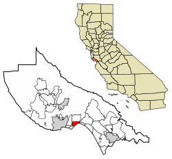
 Location in Santa Cruz County, California | |
| Coordinates: 36°58′35″N 121°57′17″W / 36.97639°N 121.95472°W | |
| Country | United States |
| State | California |
| County | Santa Cruz |
| Incorporated | January 11, 1949[1] |
| Area | |
| • Total | 1.68 sq mi (4.34 km2) |
| • Land | 1.59 sq mi (4.13 km2) |
| • Water | 0.08 sq mi (0.21 km2) 4.92% |
| Elevation | 13 ft (4 m) |
| Population (2020) | |
| • Total | 9,938 |
| • Density | 6,234.63/sq mi (2,406.54/km2) |
| Time zone | UTC−8 (PST) |
| • Summer (DST) | UTC−7 (PDT) |
| ZIP codes | 95010, 95062 |
| Area code | 831 |
| FIPS code | 06-11040 |
| GNIS feature IDs | 1658216, 2409981 |
| Website | Official website |
Capitola is a small seaside town in Santa Cruz County, California. Capitola is located on the northern shores of Monterey Bay, on the Central Coast of California. The city had a population of 9,938 at the 2020 census. Capitola is a popular tourist destination, owing to its beaches and restaurants.
- ^ "California Cities by Incorporation Date". California Association of Local Agency Formation Commissions. Archived from the original (Word) on November 3, 2014. Retrieved August 25, 2014.
- ^ "2020 U.S. Gazetteer Files". United States Census Bureau. Retrieved October 30, 2021.
- ^ "Capitola". Geographic Names Information System. United States Geological Survey, United States Department of the Interior. Retrieved October 20, 2014.
© MMXXIII Rich X Search. We shall prevail. All rights reserved. Rich X Search


