Back كاريبو (مين) Arabic كاريبو ARZ کاریبو، مئین AZB Карибу (Мейн) Bulgarian Caribou (Maine) Catalan Карибу (Мэн) CE Caribou CEB Caribou, Maine Welsh Caribou DAG Caribou (Maine) German
Caribou, Maine | |
|---|---|
City | |
 Trucks outside a starch factory in October 1940 | |
| Nickname: The Most Northeastern City In The United States | |
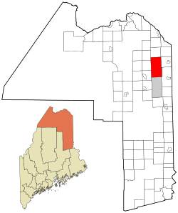
 Location of Caribou, Maine | |
| Coordinates: 46°51′49″N 67°59′53″W / 46.86361°N 67.99806°W | |
| Country | United States |
| State | Maine |
| County | Aroostook |
| Settled | 1824 |
| Incorporated (town) | April 5, 1859 |
| Incorporated (city) | February 23, 1967 |
| Named places | Barretts Grimes Mill Hurd Madawaska Maine North Lyndon |
| Government | |
| • Mayor | Jody Smith[1] |
| Area | |
| • Total | 80.09 sq mi (207.44 km2) |
| • Land | 79.29 sq mi (205.36 km2) |
| • Water | 0.80 sq mi (2.08 km2) |
| Elevation | 449 ft (137 m) |
| Population (2020) | |
| • Total | 7,396 |
| • Density | 93.28/sq mi (36.01/km2) |
| Time zone | UTC−5 (Eastern (EST)) |
| • Summer (DST) | UTC−4 (EDT) |
| ZIP code | 04736 |
| Area code | 207 |
| FIPS code | 23-10565 |
| GNIS feature ID | 0563512 |
| Website | cariboumaine |
Caribou is the second largest city in Aroostook County, Maine, United States. Its population was 7,396 at the 2020 census. The city is a service center for the agricultural and tourism industries, and the location of a National Weather Service Forecast Office.
- ^ "City Council - City of Caribou, Maine". Retrieved December 20, 2019.
- ^ "2020 U.S. Gazetteer Files". United States Census Bureau. Retrieved April 8, 2022.
© MMXXIII Rich X Search. We shall prevail. All rights reserved. Rich X Search
