Back کارنفورث AZB Carnforth (lungsod) CEB Carnforth Welsh Carnforth German Carnforth Spanish کارنفورث Persian Carnforth French Carnforth Irish Carnforth Italian Carnforth LLD
| Carnforth | |
|---|---|
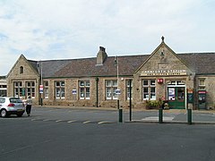
 Carnforth station in 2005 | |
Location within Lancashire | |
| Population | 5,560 (2011) |
| OS grid reference | SD499704 |
| Civil parish |
|
| District | |
| Shire county | |
| Region | |
| Country | England |
| Sovereign state | United Kingdom |
| Post town | CARNFORTH |
| Postcode district | LA5 |
| Dialling code | 01524 |
| Police | Lancashire |
| Fire | Lancashire |
| Ambulance | North West |
| UK Parliament | |
Carnforth is a market town and civil parish in the City of Lancaster in Lancashire, England, situated at the north-east end of Morecambe Bay. The parish of Carnforth had a population of 5,560 in the 2011 census,[1] an increase from the 5,350 recorded in the 2001 census.[2] The town is situated around 7 miles north of Lancaster, 17 miles south of Kendal, 40 miles east (bisected by Morecambe Bay) of Barrow-in-Furness and 28 miles northwest of Settle. The town is also close to the Cumbria/Lancashire border.
Carnforth grew in the 19th century through the presence of the railway and ironworks. Due to the closeness of the coast and the hills, Carnforth is a popular base for walkers and cyclists exploring the area. The River Keer, the West Coast Main Line (WCML), the A6 and the Lancaster Canal pass through the town. The M6 motorway passes just to the east, linked to Carnforth by the A6070 (formerly the A601(M)) which was originally part of the Lancaster bypass before the M6 was extended north.
- ^ UK Census (2011). "Local Area Report – Carnforth Parish (E04005183)". Nomis. Office for National Statistics. Retrieved 27 March 2021.
- ^ "Parish headcount" (PDF). Lancashire County Council. Archived from the original (PDF) on 10 December 2006. Retrieved 10 January 2009.
© MMXXIII Rich X Search. We shall prevail. All rights reserved. Rich X Search

