Back Carquinez-Stroß BAR Carquinez Strait CEB Carquinez-Straße German Estrecho de Carquinez Spanish تنگه کارکوئینز Persian Carquinezinsalmi Finnish Détroit de Carquinez French Estreito de Carquinez Galician Selat Carquinez ID Stretto di Carquinez Italian
| Carquinez Strait | |
|---|---|
| Spanish: Estrecho de Carquinez | |
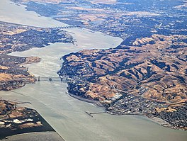
 Looking east, the Carquinez Bridge in the foreground and the Benicia–Martinez Bridge in the background | |
| Location | Bay Area, Northern California |
| Coordinates | 38°03′33″N 122°12′45″W / 38.05918°N 122.21260°W |
| Etymology | The Karkin people |
| River sources | Sacramento River, San Joaquin River |
| Primary outflows | San Pablo Bay, San Francisco Bay |
| Basin countries | United States |
| Max. length | 8 miles (13 km) |
| Settlements | Benicia, Crockett, Martinez, Vallejo |
The Carquinez Strait (/kɑːrˈkiːnəs/; Spanish: Estrecho de Carquinez)[1][2] is a narrow tidal strait located in the Bay Area of Northern California, United States. It is part of the tidal estuary of the Sacramento and the San Joaquin rivers as they drain into the San Francisco Bay. The strait is eight miles (13 km) long and connects Suisun Bay, which receives the waters of the combined rivers, with San Pablo Bay, a northern extension of the San Francisco Bay.
The strait formed in prehistoric times, near the close of one of the past ice ages, when the Central Valley was a vast inland lake. Melting ice from the Sierra Nevada raised the water level while seismic activity created a new outlet to the Pacific Ocean, draining the lake into the ocean and exposing the valley floors.
- ^ Univision Área de la Bahía - Múltiples sismos sacuden el este de la Bahía; el mayor fue de magnitud 3.8 con epicentro en San Ramón
- ^ "El temblor en el Área de la Bahía es la advertencia más reciente del alto peligro sísmico en esa zona", sandiegouniontribune.com. Accessed December 21, 2022. (in Spanish)
© MMXXIII Rich X Search. We shall prevail. All rights reserved. Rich X Search
