Back مقاطعة كارول (ماريلاند) Arabic Carroll County, Maryland BAR Керъл (окръг, Мериленд) Bulgarian কেরোল কাউন্টি, মেরিল্যান্ড BPY Carroll Gông (Maryland) CDO Кэрролл (гуо, Мэриленд) CE Carroll County (kondado sa Tinipong Bansa, Maryland) CEB Carroll County, Maryland Welsh Carroll County (Maryland) German Κομητεία Κάρολ (Μέριλαντ) Greek
Carroll County | |
|---|---|
 Carroll County Courthouse in Westminster | |
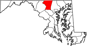
 Location within the U.S. state of Maryland | |
 Maryland's location within the U.S. | |
| Coordinates: 39°34′N 77°01′W / 39.57°N 77.02°W | |
| Country | |
| State | |
| Founded | January 19, 1837 |
| Named for | Charles Carroll of Carrollton |
| Seat | Westminster |
| Largest community | Eldersburg |
| Area | |
| • Total | 453 sq mi (1,170 km2) |
| • Land | 448 sq mi (1,160 km2) |
| • Water | 5.1 sq mi (13 km2) 1.1% |
| Population (2020) | |
| • Total | 172,891 |
| • Density | 380/sq mi (150/km2) |
| Time zone | UTC−5 (Eastern) |
| • Summer (DST) | UTC−4 (EDT) |
| Congressional districts | 2nd, 3rd |
| Website | carrollcountymd |
Carroll County is a county located in the U.S. state of Maryland. As of the 2020 census, the population was 172,891.[1] Its county seat is Westminster.[2]
Carroll County is included in the Baltimore-Columbia-Towson, MD Metropolitan Statistical Area, which is also included in the Washington-Baltimore-Arlington, DC-MD-VA-WV-PA Combined Statistical Area. While predominantly rural, the county has become increasingly suburban in recent years.
- ^ "Carroll County, Maryland". United States Census Bureau. Retrieved January 30, 2022.
- ^ "Find a County". National Association of Counties. Archived from the original on May 31, 2011. Retrieved June 7, 2011.
© MMXXIII Rich X Search. We shall prevail. All rights reserved. Rich X Search

