Back كاساس أدوبز Arabic كاساس ادوبز ARZ کاسس آدوبیز، آریزونا AZB Casas Adobes Catalan Казас-Едобс CE Casas Adobes CEB Casas Adobes German Casas Adobes Spanish Casas Adobes (Arizona) Basque کاسس آدوبیز، آریزونا Persian
Casas Adobes, Arizona | |
|---|---|
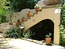
 Garden in Tohono Chul Park | |
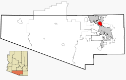
 Location in Pima County and Arizona | |
| Coordinates: 32°20′47″N 111°0′35″W / 32.34639°N 111.00972°W | |
| Country | United States |
| State | Arizona |
| County | Pima |
| Area | |
| • Total | 26.75 sq mi (69.29 km2) |
| • Land | 26.64 sq mi (69.01 km2) |
| • Water | 0.11 sq mi (0.28 km2) |
| Elevation | 2,411 ft (735 m) |
| Population (2020) | |
| • Total | 70,973 |
| • Density | 2,663.65/sq mi (1,028.43/km2) |
| Time zone | UTC-7 (MST (no DST)) |
| FIPS code | 04-10670 |
| GNIS ID | 37210 |

Casas Adobes (Spanish: "Adobe Houses") is an unincorporated community and census-designated place (CDP) located in the northern metropolitan area of Tucson, Arizona (in Pima County). The population was 66,795 at the 2010 census. Casas Adobes is situated south and southwest of the town of Oro Valley, and west of the community of Catalina Foothills.
The attempted assassination of Representative Gabby Giffords, and the murders of chief judge for the U.S. District Court for Arizona, John Roll, and five other people on January 8, 2011, took place at a Safeway supermarket in Casas Adobes.
- ^ "2020 U.S. Gazetteer Files". United States Census Bureau. Archived from the original on October 10, 2021. Retrieved October 29, 2021.
© MMXXIII Rich X Search. We shall prevail. All rights reserved. Rich X Search
