Back Catemaco (munisipyo) CEB Catemaco Esperanto Municipio de Catemaco Spanish Catemaco (udalerria) Basque Catemaco (municipalité) French Catemaco Italian Catemaco NB Catemaco Portuguese Катемако (муниципалитет) Russian Opština Catemaco, Veracruz Serbo-Croatian
Catemaco | |
|---|---|
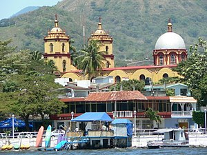
 City of Catemaco from the lake | |
| Coordinates: 18°25′0″N 95°07′0″W / 18.41667°N 95.11667°W | |
| Country | |
| State | Veracruz |
| Municipal seat | Catemaco |
| Government | |
| • Municipal President | Julio César Ortega Serrano[1] |
| Area | |
| • Total | 710.67 km2 (274.39 sq mi) |
| Elevation | 340 m (1,120 ft) |
| Population (2010) | |
| • Total | 48,593 |
| • Density | 68/km2 (180/sq mi) |
| • Municipal seat | 22,965 |
| Website | www.catemaco.gob.mx |
Catemaco Municipality is a municipality in the Mexican state of Veracruz. It is located in the state's Los Tuxtlas region. The municipal seat is the city of Catemaco.
In the 2005 INEGI Census, the municipality reported a total population of 46,702, of whom 22,965 lived in the municipal seat.[2] Ethnic composition is primarily of mestizo origins. Indigenous language speakers number less than 500.
The municipality of Catemaco covers a total surface area of 710.67 km² along the Gulf of Mexico between the foothills of Volcano San Martín Tuxtla and the Sierra Santa Marta, and incorporate Laguna Catemaco and Laguna Sontecomapan plus a large part of the Los Tuxtlas Biosphere Reserve. Catemaco borders the municipalities of San Andrés Tuxtla to the west, Hueyapan de Ocampo and Soteapan to the south and Tatahuicapan de Juárez and Mecayapan to the east.
Economically Catemaco depends on a mix of tourism, cattle ranching, fishery and agriculture. Statistically the municipality ranks as one of the poorer ones in Veracruz.
- ^ "Toma de protesta del alcalde electo de Catemaco". Diario Eyipantla (Eyipantla Newspaper) (in Spanish). 30 December 2017. Retrieved 1 January 2018.
- ^ "Catemaco". Enciclopedia de los Municipios de México. Instituto Nacional para el Federalismo y el Desarrollo Municipal. 2005. Archived from the original on 2007-05-21. Retrieved 11 November 2008.
© MMXXIII Rich X Search. We shall prevail. All rights reserved. Rich X Search
