Back مقاطعة سيدار (آيوا) Arabic Cedar County, Iowa BAR Сидър (окръг, Айова) Bulgarian সিডার কাউন্টি, আইৱা BPY Cedar Gông (Iowa) CDO Сидар (гуо, Айова) CE Cedar County (kondado sa Tinipong Bansa, Iowa) CEB Cedar County, Iowa Welsh Cedar County (Iowa) German Kantono Cedar (Iovao) Esperanto
Cedar County | |
|---|---|
 | |
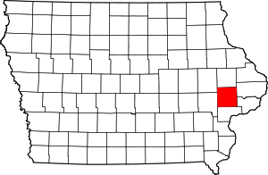
 Location within the U.S. state of Iowa | |
 Iowa's location within the U.S. | |
| Coordinates: 41°46′05″N 91°07′43″W / 41.768055555556°N 91.128611111111°W | |
| Country | |
| State | |
| Founded | 1837 |
| Named for | Cedar River |
| Seat | Tipton |
| Largest city | Tipton |
| Area | |
| • Total | 582 sq mi (1,510 km2) |
| • Land | 579 sq mi (1,500 km2) |
| • Water | 2.5 sq mi (6 km2) 0.4% |
| Population (2020) | |
| • Total | 18,505 |
| • Density | 32/sq mi (12/km2) |
| Time zone | UTC−6 (Central) |
| • Summer (DST) | UTC−5 (CDT) |
| Congressional district | 2nd |
| Website | cedarcounty |
Cedar County is a county located in the U.S. state of Iowa. As of the 2020 census, the population was 18,505.[1] Its county seat is Tipton.[2] The county is named for the Cedar River, which runs through the county.
Cedar County is located between the Cedar Rapids, Quad Cities and Iowa City metropolitan areas, areas also known as the "Tri-Metro" county. It is the only Iowa county which shares the name of a tree. Cedar County was the focus of the Iowa Cow War of 1931.
- ^ "2020 Census State Redistricting Data". census.gov. United states Census Bureau. Retrieved August 12, 2021.
- ^ "Find a County". National Association of Counties. Archived from the original on May 31, 2011. Retrieved June 7, 2011.
© MMXXIII Rich X Search. We shall prevail. All rights reserved. Rich X Search