Back Forêts claires ripariennes d'Asie centrale French Boschi ripariani dell'Asia centrale Italian Центральноазійські прибережні рідколісся Ukrainian
| Central Asian riparian woodlands | |
|---|---|
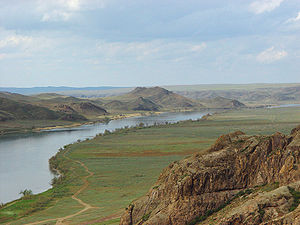
 Ili River, in Kazakhstan | |
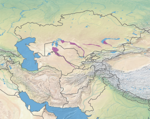
 Ecoregion territory (in purple) | |
| Ecology | |
| Realm | Palearctic |
| Biome | Deserts and xeric shrublands |
| Geography | |
| Area | 88,578 km2 (34,200 sq mi) |
| Country | Kazakhstan, Uzbekistan, Turkmenistan, Tajikistan |
| Coordinates | 43°N 59°E / 43°N 59°E |
The Central Asian riparian woodlands ecoregion (WWF ID: PA1311) is spread out across the deserts and plains of central Asia between the Aral Sea and the mountains 2,000 kilometres (1,200 mi) to the east. The long narrow components of the ecoregion follow the large rivers fed by snowmelt, and provide critical habitat for migratory birds as they travel through the arid region. The vegetation is referred to as tugai, characterized by low tangles of trees and brush along the edges of the rivers and associated wetlands, and fed by groundwater instead of precipitation.[1][2]
- ^ "Central Asian Riparian Woodlands". World Wildlife Federation (WWF). Retrieved December 28, 2019.
- ^ "Map of Ecoregions 2017". Resolve, using WWF data. Retrieved September 14, 2019.
© MMXXIII Rich X Search. We shall prevail. All rights reserved. Rich X Search