Back سنتراليا (واشنطن) Arabic سنتراليا ARZ سنترالیا، واشینقتون AZB Сентралия Bulgarian Centralia (Washington) Catalan Сентрейлия (Вашингтон) CE Centralia (lungsod sa Tinipong Bansa, Washington) CEB Centralia, Washington Welsh Centralia (Washington) Danish Centralia (Washington) German
This article needs additional citations for verification. (October 2011) |
Centralia | |
|---|---|
 Centralia downtown historic district | |
| Nickname(s): Hub City, City of Azaleas[1] | |
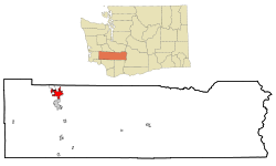
 Location of Centralia, Washington | |
| Coordinates: 46°43′14″N 122°57′41″W / 46.72056°N 122.96139°W | |
| Country | United States |
| State | Washington |
| County | Lewis |
| Government | |
| • Type | Council–manager |
| • Mayor | Kelly Smith Johnston[2] |
| Area | |
| • Total | 7.81 sq mi (20.22 km2) |
| • Land | 7.62 sq mi (19.74 km2) |
| • Water | 0.19 sq mi (0.48 km2) |
| Elevation | 187 ft (57 m) |
| Population | |
| • Total | 18,183 |
| • Estimate (2021)[5] | 18,629 |
| • Density | 2,386.22/sq mi (921.12/km2) |
| Time zone | UTC-8 (PST) |
| • Summer (DST) | UTC-7 (PDT) |
| ZIP code | 98531 |
| Area code | 360 |
| FIPS code | 53-11160 |
| GNIS feature ID | 1503899[6] |
| Website | cityofcentralia.com |
Centralia (/sɛnˈtreɪliə/) is a city in Lewis County, Washington, United States. It is located along Interstate 5 near the midpoint between Seattle and Portland, Oregon. The city had a population of 18,183 at the 2020 census.[4] Centralia is twinned with Chehalis, located to the south near the confluence of the Chehalis and Newaukum rivers.
- ^ Crowner, Paul (June 21, 2010). "Lutheran Coffee and Lattes for the Lord". The Chronicle. Retrieved April 17, 2024.
- ^ "Kelly Smith Johnston". City of Centralia. Archived from the original on December 1, 2021. Retrieved April 4, 2022.
- ^ "2019 U.S. Gazetteer Files". United States Census Bureau. Retrieved August 7, 2020.
- ^ a b "Explore Census Data". United States Census Bureau. Retrieved March 12, 2022.
- ^ Cite error: The named reference
USCensusEst2021was invoked but never defined (see the help page). - ^ "Centralia". Geographic Names Information System. United States Geological Survey, United States Department of the Interior.
© MMXXIII Rich X Search. We shall prevail. All rights reserved. Rich X Search
