Back بحيره باسين د تشامبلى ARZ Bassin de Chambly CEB Bassin de Chambly French Bassin de Chambly Swedish
| Chambly Basin | |
|---|---|
| bassin de Chambly (French) | |
 | |
| Location | Chambly, Montérégie, Quebec, Canada |
| Coordinates | 45°27′40″N 73°17′00″W / 45.46111°N 73.28333°W |
| Type | basin |
| Primary inflows | (clockwise) ruisseau Wilson, rivière des Hurons, Richelieu River, Chambly Canal |
| Primary outflows | Richelieu River |
| Basin countries | Canada |
| Max. length | 1.98 mi (3.18 km) |
| Max. width | 1.34 mi (2.16 km) |
| Surface elevation | 11 to 100 ft (3.4 to 30.5 m) |
| Settlements | Richelieu, Saint-Mathias-sur-Richelieu, Carignan and Chambly |
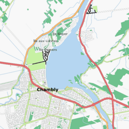
The Chambly Basin (French: bassin de Chambly) is a shallow, oblong body of water formed by an enlargement of the Richelieu River, extending out from the foot of the rapids on the river between Chambly and Richelieu, in the Quebec region of Montérégie. The towns of Chambly, Richelieu, Saint-Mathias-sur-Richelieu and Carignan surround the basin.
The Chambly Basin is an important area for recreational tourism activities including boating in the summer, the connected Chambly Canal and nearby Fort Chambly National Historic Sites. Its surface is generally frozen from mid-December to the end of March. The water level of the river varies with the seasons and the precipitation.
© MMXXIII Rich X Search. We shall prevail. All rights reserved. Rich X Search
