| Channel Islands Harbor | |
|---|---|
 Scene from commercial fishing boat unloading pier facing southeast with hotel in background | |
 Click on the map for a fullscreen view | |
| Location | |
| Country | United States |
| Location | Oxnard, California |
| Coordinates | 34°10′12″N 119°13′30″W / 34.17°N 119.225°W |
| Details | |
| Opened | 1960 |
| Owned by | County of Ventura[1] |
| Type of harbour | Artificial |
| Size of harbour | 166 acres (67 ha) |
| Land area | 126 acres (51 ha) |
| No. of berths | 2,150 |
| Statistics | |
| Website channelislandsharbor | |
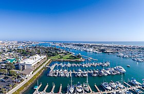
Channel Islands Harbor is a small craft harbor[2] and shore-protection project[3] in Oxnard, California at the southern end of the Santa Barbara Channel. It is the fifth largest harbor for small-craft recreation in the state of California[4] and is a waterfront resort, recreation, and dining marketplace. Recreational activities include diving, boat charters, sea kayaking, sportfishing, and whale watching (gray whales January through early April; blue and humpback whales July to September).
The horseshoe shaped harbor contains 166 acres (0.67 km2) of water surrounded by 126 acres (0.51 km2) of land[5] and supports more than 2,500 vessels,[6] four yacht clubs, and nine full-service marinas.[7] The five Channel Islands are a popular destination, the closest of which is Anacapa Island.[4] The Ventura County Maritime Museum has a regularly rotating exhibit, maritime-themed art, and model ships. Water taxis are available to drop diners and shoppers at various docks within the harbor.[8] Every three years the harbor is host to the Channel Islands Tall Ships Festival[9] which includes between two and five large sailing vessels and draws thousands of visitors.[6]
- ^ Channel Islands Harbor Website "About Us/Harbor Information" Accessed 24 Dec 2013
- ^ United States Army Corps of Engineers, South Pacific Division (1973). Water resources development by the U.S. Army Corps of Engineers in California. University of California Libraries. p. 89. ISBN 978-1-125-52499-2.
- ^ Herron, William J.; Harris, Robert L. (1966) LITTORAL BYPASSING AND BEACH RESTORATION IN THE VICINITY OF PORT HUENEME CALIFORNIA Proceedings of 10th Conference on Coastal Engineering, Tokyo, Japan
- ^ a b Travis, William, ed. (2006). Fodor's Southern California (Second ed.). New York: Random House. p. 385. ISBN 978-1-4000-1603-7.
- ^ Smith, Patricia (1998). "Channel Islands Harbor Master Plan" (PDF). Archived from the original (PDF) on October 3, 2011. Retrieved May 1, 2011.
- ^ a b Cite error: The named reference
r1was invoked but never defined (see the help page). - ^ Harris, Elanor; Lichtig, Claudia Harris (2006). Quick escapes Los Angeles: 20 weekend getaways from the metro area (7th ed.). Guilford, CT: Globe Pequot Press. pp. 124. ISBN 978-0-7627-4219-6.
- ^ Marcum, Diana (July 4, 1999). "Water Taxi! Water Taxi!". Los Angeles Times.
- ^ "Tall Ships Relocate to Channel Islands Harbor Through Feb. 15th". Ventura Harbor Village. Retrieved December 29, 2022.
© MMXXIII Rich X Search. We shall prevail. All rights reserved. Rich X Search
