Back چنقا، آلاسکا AZB Chenega Catalan Ченега (Аляска) CE Chenega German Chenega (Alaska) Spanish چنگا، آلاسکا Persian Chenega French Chenega Italian Chenega (Alaska) LLD चेनेहा, अलास्का NEW
Chenega, Alaska
Caniqaq | |
|---|---|
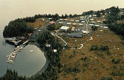
 Aerial of Chenega Bay Village and boat harbor - Chenega Bay, Evans Island, 1989 | |
 Location of Chenega, Alaska | |
| Coordinates: 60°3′59″N 148°0′40″W / 60.06639°N 148.01111°W | |
| Country | United States |
| State | Alaska |
| Census Area | Chugach |
| Government | |
| • State senator | Gary Stevens (R) |
| • State rep. | Louise Stutes (R) |
| Area | |
| • Total | 29.56 sq mi (76.57 km2) |
| • Land | 29.29 sq mi (75.85 km2) |
| • Water | 0.28 sq mi (0.72 km2) |
| Population (2020) | |
| • Total | 59 |
| • Density | 2.01/sq mi (0.78/km2) |
| Time zone | UTC-9 (Alaska (AKST)) |
| • Summer (DST) | UTC-8 (AKDT) |
| Area code | 907 |
| FIPS code | 02-12970 |
Chenega (/tʃɪˈniːɡə/; Alutiiq: Caniqaq) is a census-designated place (CDP) on Evans Island in the Chugach Census Area in the U.S. state of Alaska. Located in Prince William Sound, the CDP consists of the Chugach Alutiiq village of Chenega Bay, which was established only after the Good Friday earthquake destroyed the original community on Chenega Island to the north. As of the 2020 census, the population of the CDP was 59, largely Alaska Natives; as of 2021, the population of Chenega is estimated at 49. Chenega Bay is in the Chugach School District and has one school, Chenega Bay Community School, serving approximately 16 students from preschool through high school.
- ^ "2020 U.S. Gazetteer Files". United States Census Bureau. Retrieved October 29, 2021.
© MMXXIII Rich X Search. We shall prevail. All rights reserved. Rich X Search