Back Qamdo CEB Čhamdo Czech Chengguan (Karub) German چنگوان چامدو Persian Chengguan, Chamdo French Čamdo Lithuanian Qamdo Malagasy Qamdo Malay Chamdo (stad) Dutch Chengguan (Qamdo) Polish
Chengguan
城关镇 · ཁྲིན་ཀོན་རྡལ། | |
|---|---|
 | |
| Coordinates: 31°08′27″N 97°10′19″E / 31.14083°N 97.17194°E | |
| Country | China |
| Autonomous region | Tibet Autonomous Region |
| Prefecture | Qamdo |
| District | Karub |
| Area | |
| • Total | 195.39 km2 (75.44 sq mi) |
| Elevation | 3,256 m (10,682 ft) |
| Population (2010)[1] | |
| • Total | 45,861 |
| Time zone | UTC+08:00 (China Standard) |
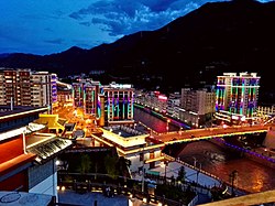
Chengguan (Tibetan: ཁྲེང་ཀོན་གྲོང་རྡལ, Wylie: Khreng kon grong rdal, ZYPY: Chênggoin Chongdai; Chinese: 城关镇; pinyin: Chéngguān Zhèn) is a major town in the historical region of Kham in the eastern Tibet Autonomous Region of China. It is the seat of Karub District and Chamdo Prefecture, and had a population of 45,861 in 2010.[1] It is located about 600 km (370 mi) east of Lhasa. By road, the distance is 1,120 km (700 mi) via the southern route or 1,030 km (640 mi) via the northern route.[2] It is at an altitude of 3,230 m (10,600 ft) at the confluence of the rivers Za Qu and Ngom Qu which form the Lancang River (Mekong).[3]
At the turn of the 20th century it had a population of about 12,000, a quarter of whom were monks.[4]
- ^ a b "Chéngguān Zhèn". City Population. Thomas Brinkhoff. Retrieved 20 September 2017.
- ^ Distances calculated acc. to "China Road Atlas, Zhongguo Gaosugonglu Ji Chengxiang Gongluwang Diutuji", Renmin Jiaotong Chunbanshe, Beijing 2006, p. 338. ISBN 7-114-05339-8
- ^ Atlas of China. Beijing, China: SinoMaps Press. 2006. ISBN 9787503141782.
- ^ Buckley and Straus 1986, p. 215.
© MMXXIII Rich X Search. We shall prevail. All rights reserved. Rich X Search
