Back تشيشير إيست Arabic Cheshire East CEB Dwyrain Swydd Gaer Welsh Cheshire East German چشر شرقی Persian Cheshire East French Cheshire East FRR Cheshire East Italian 체셔이스트 Korean Cheshire East Dutch
Cheshire East | |
|---|---|
 Crewe, a historic railway town and the largest town in Cheshire East | |
| Motto: Working together for excellence | |
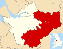
 Cheshire East shown within Cheshire | |
| Coordinates: 53°08′46″N 2°22′01″W / 53.146°N 2.367°W | |
| Sovereign state | United Kingdom |
| Country | England |
| Region | North West |
| Ceremonial county | Cheshire |
| Incorporated | 1 April 2009 |
| Administrative HQ | Westfields, Sandbach |
| Government | |
| • Type | Unitary authority |
| • Body | Cheshire East Council |
| • Executive | Committee system |
| • Control | No overall control |
| • Leader | Sam Corcoran (L) |
| • Mayor | Rod Fletcher |
| • MPs | 5 MPs
|
| Area | |
| • Total | 450 sq mi (1,166 km2) |
| • Rank | 19th |
| Population (2022)[3] | |
| • Total | 406,527 |
| • Rank | 16th |
| • Density | 900/sq mi (349/km2) |
| Ethnicity (2021) | |
| • Ethnic groups | |
| Religion (2021) | |
| • Religion | List
|
| Time zone | UTC+0 (GMT) |
| • Summer (DST) | UTC+1 (BST) |
| Postcode areas | |
| Dialling codes |
|
| ISO 3166 code | GB-CHE |
| GSS code | E06000049 |
| Website | cheshireeast |
Cheshire East is a unitary authority area with borough status in Cheshire, England. The local authority is Cheshire East Council, which is based in the town of Sandbach. Other towns within the area include Crewe, Macclesfield, Congleton, Wilmslow, Nantwich, Poynton, Knutsford, Alsager, Bollington and Handforth.
- ^ "Council and Democracy". Cheshire East Council. Retrieved 13 January 2024.
- ^ "Mid-Year Population Estimates, UK, June 2022". Office for National Statistics. 26 March 2024. Retrieved 3 May 2024.
- ^ "Mid-Year Population Estimates, UK, June 2022". Office for National Statistics. 26 March 2024. Retrieved 3 May 2024.
- ^ a b UK Census (2021). "2021 Census Area Profile – Cheshire East Local Authority (E06000049)". Nomis. Office for National Statistics. Retrieved 17 December 2023.
© MMXXIII Rich X Search. We shall prevail. All rights reserved. Rich X Search
