Back Chevening (lungsod) CEB Chevening, Caint Welsh Chevening Spanish چونینگ، کنت Persian Chevening (Kent) French Chevening Italian Chevening Dutch Chevening NB Chevening Polish Chevening Swedish
| Chevening | |
|---|---|
 Chevening | |
Location within Kent | |
| Population | 3,092 (2011 Census)[1] |
| OS grid reference | TQ4857 |
| Civil parish |
|
| District | |
| Shire county | |
| Region | |
| Country | England |
| Sovereign state | United Kingdom |
| Post town | SEVENOAKS |
| Postcode district | TN14 |
| Dialling code | 01732 |
| Police | Kent |
| Fire | Kent |
| Ambulance | South East Coast |
| UK Parliament | |
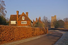
Chevening (/ˈtʃiːvnɪŋ/) is a village and civil parish in the Sevenoaks District of Kent, England. It was the location for the world's earliest known organised cricket match.
The parish is located to the north west of Sevenoaks on the southern slopes of the North Downs. The parish is a small one, being 6.5 miles (10.5 km) in length and 1 mile (1.6 km) wide. It had a population of 3,092 at the 2011 Census.[1] Apart from the village the remaining area is rural. Chevening House is located here. The Pilgrims' Way crosses the parish. Close to Chevening, the path of Harold Godwinson's army en route to the Battle of Hastings in 1066, heading south along what is now Chipstead Lane, crosses William the Conqueror's route after the battle towards London along the Pilgrim's Way.
The village of Chevening is also small. It stands on the upper reaches of the River Darent. The village lies very close to the M25 motorway.
- ^ a b "Civil Parish population 2011". Neighbourhood Statistics. Office for National Statistics. Archived from the original on 20 October 2016. Retrieved 18 September 2016.
© MMXXIII Rich X Search. We shall prevail. All rights reserved. Rich X Search
