Back Chew Valley Lake CEB Lago de Valle Chew Spanish Chew haraneko aintzira Basque Lac de Chew Valley French Lago Chew Valley IO Chew Valley (jezioro) Polish Chew Valley Lake Swedish 丘谷湖 Chinese
| Chew Valley Lake | |
| Governing body | Bristol Water |
| SSSI Ref | 1001346 |
| SPA Code | UK9010041 |
| Chew Valley Lake | |
|---|---|
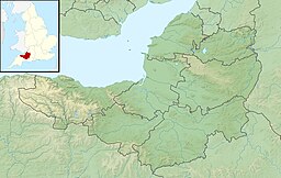
 Map | |
| Location | Somerset |
| Coordinates | 51°20′4.92″N 2°37′4.92″W / 51.3347000°N 2.6180333°W |
| Lake type | Reservoir |
| Primary inflows | River Chew |
| Primary outflows | River Chew |
| Catchment area | 14,000 acres (57 km2) |
| Basin countries | United Kingdom |
| Surface area | 1,200 acres (4.9 km2) |
| Average depth | 14 ft (4.3 m) |
| Max. depth | 37 ft (11 m) |
| Water volume | 4,500,000,000 imp gal (0.020 km3) |
| Islands | Denny Island |
Chew Valley Lake (grid reference ST5659) is a reservoir in Chew Stoke, Chew Valley, Somerset, England. It is the fifth-largest artificial lake in the United Kingdom, with an area of 1,200 acres (4.9 km2). The lake, created in the early 1950s, was opened by Queen Elizabeth II in 1956. It provides much of the drinking water for the city of Bristol and surrounding area, taking its supply from the Mendip Hills. Some of the lake water is used to maintain the flow in the River Chew.
Before the lake was created, archaeological investigations were carried out that showed evidence of occupation since Neolithic times and included Roman artefacts. The lake is an important site for wildlife and has been designated a Site of Special Scientific Interest (SSSI) and a Special Protection Area (SPA). It is a national centre for birdwatching, with over 260 species recorded. The lake has indigenous and migrant water birds throughout the year, and two nature trails have been created. The flora and fauna provide habitats for some less common plants and insects.
Some restricted use for recreational activities is permitted by the owner, Bristol Water, including dinghy sailing and fishing, primarily for trout.
© MMXXIII Rich X Search. We shall prevail. All rights reserved. Rich X Search
