Back شيا يي Arabic شيا يى ARZ Txiayi Catalan Gă-ngiê (chê) CDO Chiayi (lalawigan sa Republika sa Tsina, lat 23,48, long 120,45) CEB Ťia-i Czech Chiayi German Τσιαγί Greek Ĉjaji Esperanto Chiayi Spanish
Chiayi City
嘉義市 Ka-gi, Kagi, Chiai, Chia-i | |
|---|---|
| Chiayi City | |
Clockwise from top left: Hinoki Village, Chiayi Confucius Temple, Fountain at the Lantan Reservoir, Chiayi City Sports Arena, Chiayi Municipal Culture Center, Chiayi Sun Shooting Tower, National Chiayi University | |
| Nickname: Peach City (桃城) or Jia City (嘉市) | |
 | |
 | |
| Country | |
| Province | |
| Region | Southwestern Taiwan |
| First mentioned | 1787 |
| Renamed to Kagi | 17 April 1895 |
| Autonomous city | 1930 |
| Provincial city | 25 October 1945 |
| Downgraded to county-administered city | 16 August 1950 |
| Provincial city status restored | 1 July 1982 |
| Seat | East District |
| Districts | |
| Government | |
| • Type | Chiayi City Government |
| • Mayor | Huang Min-hui (KMT) |
| Area | |
| • Total | 60.03 km2 (23.18 sq mi) |
| • Rank | 21 out of 22 |
| Elevation | 69 m (226 ft) |
| Population (January 2023)[2] | |
| • Total | 263,188 |
| • Rank | 18 of 22 |
| • Density | 4,400/km2 (11,000/sq mi) |
| Time zone | UTC+8 (National Standard Time) |
| Postal code | 600 |
| Area code | 05 |
| ISO 3166 code | TW-CYI |
| Flower |
|
| Tree | Hong Kong orchid tree |
| Website | www |
| Chiayi City | |||||||||||||||||||||||||||||||||||||||
|---|---|---|---|---|---|---|---|---|---|---|---|---|---|---|---|---|---|---|---|---|---|---|---|---|---|---|---|---|---|---|---|---|---|---|---|---|---|---|---|
 "Chiayi" in Traditional (top) and Simplified (bottom) Chinese characters | |||||||||||||||||||||||||||||||||||||||
| Chinese name | |||||||||||||||||||||||||||||||||||||||
| Traditional Chinese | 嘉義市 | ||||||||||||||||||||||||||||||||||||||
| Simplified Chinese | 嘉义市 | ||||||||||||||||||||||||||||||||||||||
| |||||||||||||||||||||||||||||||||||||||
| Japanese name | |||||||||||||||||||||||||||||||||||||||
| Kanji | 嘉義市 | ||||||||||||||||||||||||||||||||||||||
| Hiragana | かぎし | ||||||||||||||||||||||||||||||||||||||
| Katakana | カギシ | ||||||||||||||||||||||||||||||||||||||
| |||||||||||||||||||||||||||||||||||||||
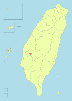
Chiayi (/ˈdʒjɑːˈiː/,[3] Taigi POJ: Ka-gī; Chinese: 嘉義), officially known as Chiayi City, is a city located in Chianan Plain in southwestern Taiwan, surrounded by Chiayi County with a population of 263,188 inhabitants as of January 2023.
Hoanya people inhabited present-day Chiayi under its historical name Tirosen prior to the arrival of Han Chinese in Taiwan and was ruled by the Dutch and Kingdom of Tungning under various names. During the Qing dynasty, Tirosen was governed as part of Taiwan Prefecture in Fujian under Zhuluo County and the city was renamed to Kagee in 1787. The city was once again named Kagi during the Japanese era but the earthquake destroyed much of the town. Kagi became administered as part of Tainan Prefecture from 1920. Following the surrender of Japan, the Republic of China, who deposed the Qing in 1911, took control of the city in 1945 as Chiayi City and became administered as a provincial city of Taiwan Province before being integrated in Chiayi County in 1950 as a county-administered city and later restored its status as provincial city in 1982. In 1998, Taiwan Province became streamlined and Chiayi City became governed directly by the Executive Yuan.
The city is known for Alishan National Scenic Area and warm humid subtropical climate in the summer months. Left with the landmarks of Japanese colonial rule, Chiayi City has the round-island railway system and Alishan Forest Railway where the city is the starting point along with various Japanese temples.
- ^ "Xiàn shì zhòngyào tǒngjì zhǐbiāo cháxún xìtǒng wǎng" 縣市重要統計指標查詢系統網. Zhōnghuá mínguó tǒngjì zīxùn wǎng 中華民國統計資訊網 (in Chinese). Archived from the original on 12 June 2016. Retrieved 1 July 2016.
- ^ Minzheng chu (2016-07-01). "Jiāyì Shì 105 nián 6 yuèfèn rénkǒu tǒngjì zīliào" 嘉義市105年6月份人口統計資料 [Population Statistics of Chiayi City for June 2016]. Jiāyì Shì zhèngfǔ 嘉義市政府 (in Chinese). Archived from the original on 16 September 2016. Retrieved 1 July 2016.
- ^ "Chia-i". Merriam-Webster.com Dictionary.
© MMXXIII Rich X Search. We shall prevail. All rights reserved. Rich X Search


