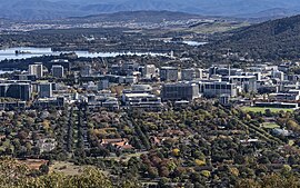
| Civic Canberra, Australian Capital Territory | |||||||||||||||
|---|---|---|---|---|---|---|---|---|---|---|---|---|---|---|---|
 | |||||||||||||||
 | |||||||||||||||
| Coordinates | 35°16′55″S 149°07′43″E / 35.282°S 149.1286°E | ||||||||||||||
| Population | 4,835 (2021 census)[1] | ||||||||||||||
| • Density | 3,220/km2 (8,350/sq mi) | ||||||||||||||
| Established | 1927 | ||||||||||||||
| Gazetted | 20 September 1928 | ||||||||||||||
| Postcode(s) | 2601 | ||||||||||||||
| Elevation | 577 m (1,893 ft) | ||||||||||||||
| Area | 1.5 km2 (0.6 sq mi) | ||||||||||||||
| Location |
| ||||||||||||||
| District | Canberra Central (North Canberra) | ||||||||||||||
| Territory electorate(s) | Kurrajong | ||||||||||||||
| Federal division(s) | Canberra | ||||||||||||||
| |||||||||||||||
Civic is the city centre or central business district of Canberra. "Civic" is a common name for the district, but it is also called Civic Centre, City Centre, Canberra City and Canberra, and its official division name is City.[2]
Canberra's City was established in 1927, although the division name City was not gazetted until 20 September 1928. Walter Burley Griffin's design for Canberra included a "Civic Centre" with a separate "Market Centre" located at what is now Russell. However then Prime Minister Stanley Bruce vetoed this idea and only the Civic Centre was developed; the idea of the Market Centre was abandoned.
- ^ Australian Bureau of Statistics (28 June 2022). "City (SSC)". 2021 Census QuickStats. Retrieved 14 July 2022.
- ^ "Search for street and suburb names: City". Environment and Planning Directorate. ACT Government. Archived from the original on 23 November 2015. Retrieved 23 November 2015.
© MMXXIII Rich X Search. We shall prevail. All rights reserved. Rich X Search

