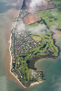
Clarks Beach | |
|---|---|
 Aerial view of Clarks Beach | |
 | |
| Coordinates: 37°08′06″S 174°42′07″E / 37.135°S 174.702°E | |
| Country | |
| Region | Auckland Region |
| Territorial authority | Auckland Council |
| Ward | Franklin ward |
| Board | Franklin Local Board |
| Electorates | |
| Area | |
| • Total | 2.41 km2 (0.93 sq mi) |
| Population (June 2023)[2] | |
| • Total | 1,520 |
| • Density | 630/km2 (1,600/sq mi) |
Clarks Beach is a small town of Auckland, New Zealand. It is in the former Franklin District local government area.
Primarily a beachside rural town, situated within the Manukau Harbour, at the mouth of the Waiuku River, it fronts the harbour and is north facing. It is known as one of the few beaches where scallops can be collected by hand at low tide.
About 50 ha immediately to the east of the existing town was rezoned to allow mixed housing in 2016.[3] The Clarks Beach Waterfront Estate development started subsequently in 2019.
Seagrove aerodrome operated near Clarks Beach during World War II.
- ^ Cite error: The named reference
Areawas invoked but never defined (see the help page). - ^ "Population estimate tables - NZ.Stat". Statistics New Zealand. Retrieved 25 October 2023.
- ^ "Rezoning and Residential Subdivision, Clarks Beach". Civil Plan Consultants. Retrieved 15 September 2020.
© MMXXIII Rich X Search. We shall prevail. All rights reserved. Rich X Search
