Back مقاطعة كلاي (أركنساس) Arabic Clay County, Arkansas BAR Клей (окръг, Арканзас) Bulgarian ক্লে কাউন্টি, আরকান্সাস BPY Clay Gông (Arkansas) CDO Клей (гуо, Арканзас) CE Clay County (kondado sa Tinipong Bansa, Arkansas) CEB Clay County, Arkansas Welsh Clay County (Arkansas) Danish Clay County (Arkansas) German
Clay County | |
|---|---|
 | |
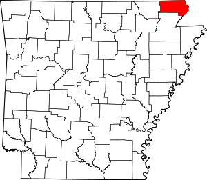
 Location within the U.S. state of Arkansas | |
 Arkansas's location within the U.S. | |
| Coordinates: 36°22′39″N 90°26′07″W / 36.3775°N 90.435277777778°W | |
| Country | |
| State | |
| Founded | 24 March, 1873 |
| Seat | Corning (western district); Piggott (eastern district) |
| Largest city | Piggott |
| Area | |
| • Total | 641 sq mi (1,660 km2) |
| • Land | 639 sq mi (1,660 km2) |
| • Water | 2.0 sq mi (5 km2) 0.3% |
| Population (2020) | |
| • Total | 14,552 |
| • Density | 23/sq mi (8.8/km2) |
| Time zone | UTC−6 (Central) |
| • Summer (DST) | UTC−5 (CDT) |
| Congressional district | 1st |
| Website | claycounty |
Clay County is a county located in the U.S. state of Arkansas. Originally incorporated as Clayton County, as of the 2020 census, its population was 14,552.[1] The county has two county seats, Corning and Piggott.[2] It is a dry county, in which the sale of alcoholic beverages is restricted or prohibited.
- ^ "Census - Geography Profile: Clay County, Arkansas". United States Census Bureau. Retrieved 19 January 2023.
- ^ "Find a County". National Association of Counties. Archived from the original on 31 May 2011. Retrieved 7 June 2011.
© MMXXIII Rich X Search. We shall prevail. All rights reserved. Rich X Search