Back كلايتون (إنديانا) Arabic Clayton (Indiana) Catalan Клейтон (Индиана) CE Clayton (lungsod sa Tinipong Bansa, Indiana) CEB Clayton (Indiana) Spanish Clayton (Indiana) Basque Clayton (Indiana) French Clayton, Indiana HT Clayton (Indiana) Italian Clayton (Indiana) LLD
Clayton, Indiana | |
|---|---|
 Town Hall | |
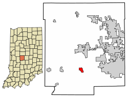
 Location of Clayton in Hendricks County, Indiana. | |
| Coordinates: 39°41′19″N 86°31′22″W / 39.68861°N 86.52278°W | |
| Country | United States |
| State | Indiana |
| County | Hendricks |
| Township | Liberty |
| Area | |
| • Total | 0.65 sq mi (1.68 km2) |
| • Land | 0.65 sq mi (1.68 km2) |
| • Water | 0.00 sq mi (0.00 km2) |
| Elevation | 876 ft (267 m) |
| Population (2020) | |
| • Total | 908 |
| • Density | 1,396.92/sq mi (539.58/km2) |
| Time zone | UTC-5 (EST) |
| • Summer (DST) | UTC-5 (EST) |
| ZIP code | 46118 |
| Area code | 317 |
| FIPS code | 18-13366[3] |
| GNIS feature ID | 2396652[2] |
| Website | www |

Clayton is a small town in Liberty Township, Hendricks County, Indiana, United States. The population was 972 at the 2010 census,[4] up from 693 at the 2000 census.
- ^ "2020 U.S. Gazetteer Files". United States Census Bureau. Retrieved March 16, 2022.
- ^ a b U.S. Geological Survey Geographic Names Information System: Clayton, Indiana
- ^ "U.S. Census website". United States Census Bureau. Retrieved January 31, 2008.
- ^ "Geographic Identifiers: 2010 Demographic Profile Data (G001): Clayton town, Indiana". American Factfinder. U.S. Census Bureau. Retrieved June 20, 2017.[dead link]
© MMXXIII Rich X Search. We shall prevail. All rights reserved. Rich X Search