Back Clerkenwell Afrikaans كليركينويل Arabic کلارکنول AZB Clerkenwell CEB Clerkenwell Esperanto Clerkenwell Spanish کلارکنول Persian Clerkenwell Finnish Clerkenwell French Clerkenwell Frisian
| Clerkenwell | |
|---|---|
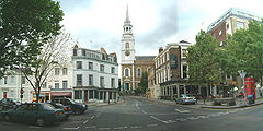
 Clerkenwell Green and St James's Church | |
Location within Greater London | |
| Population | 11,490 (2011 Census. Ward)[1] |
| OS grid reference | TQ315825 |
| London borough | |
| Ceremonial county | Greater London |
| Region | |
| Country | England |
| Sovereign state | United Kingdom |
| Post town | LONDON |
| Postcode district | EC1 |
| Postcode district | WC1 |
| Dialling code | 020 |
| Police | Metropolitan |
| Fire | London |
| Ambulance | London |
| UK Parliament | |
| London Assembly | |
Clerkenwell (/ˈklɑːrkənwɛl/) is an area of central London, England.
Clerkenwell was an ancient parish from the medieval period onwards, and now forms the south-western part of the London Borough of Islington. The church of St James in Clerkenwell Close and nearby Clerkenwell Green sit at the center of Clerkenwell. Located on the edge of the City of London, it was the home of the Priory of St John and the site of a number of wells and spas, including Sadlers Wells and Spa Green. The well after which the area was named was rediscovered in 1924.
The Marquess of Northampton owned much of the land in Clerkenwell, reflected in placenames such as Northampton Square, Spencer Street and Compton Street.
The watchmaking and watch repairing trades were once of great importance, particularly in the area around Northampton Square.[2] In the 20th century, Clerkenwell became known as a centre for architecture and design.
Clerkenwell is home to City University and the Royal Mail's Mount Pleasant sorting office. It includes the neighbourhoods of Farringdon and Exmouth Market.
- ^ "Islington Ward population 2011". Neighbourhood Statistics. Office for National Statistics. Archived from the original on 24 October 2016. Retrieved 24 October 2016.
- ^ Moore, W. G. (1971) The Penguin Encyclopedia of Places. Harmondsworth: Penguin Books; p. 178
© MMXXIII Rich X Search. We shall prevail. All rights reserved. Rich X Search
