Back كليفلاند هايتس (أوهايو) Arabic كليفلاند هايتس ARZ کلیولند هایتس، اوهایو AZB Cleveland Heights Catalan Кливленд-Гайтс (Огайо) CE Cleveland Heights (lungsod) CEB Cleveland Heights, Ohio Welsh Cleveland Heights DAG Cleveland Heights German Cleveland Heights (Ohio) Spanish
This article needs additional citations for verification. (May 2023) |
Cleveland Heights, Ohio | |
|---|---|
 | |
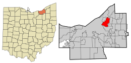
 Location in Cuyahoga County and the state of Ohio. | |
| Coordinates: 41°30′35″N 81°33′48″W / 41.50972°N 81.56333°W | |
| Country | United States |
| State | Ohio |
| County | Cuyahoga |
| Founded | 1903 (Village) |
| Established | August 9, 1921 (City) |
| Government | |
| • Type | Mayor–council |
| • Mayor | Kahlil Seren[1] |
| Area | |
| • Total | 8.08 sq mi (20.94 km2) |
| • Land | 8.06 sq mi (20.89 km2) |
| • Water | 0.02 sq mi (0.05 km2) |
| Elevation | 942 ft (287 m) |
| Population (2020) | |
| • Total | 45,312 |
| • Density | 5,618.35/sq mi (2,169.15/km2) |
| Time zone | UTC-5 (Eastern (EST)) |
| • Summer (DST) | UTC-4 (EDT) |
| ZIP codes | 44106, 44112, 44118, 44121 |
| Area code | 216 |
| FIPS code | 39-16014[4] |
| GNIS feature ID | 1048605[3] |
| Website | www |
Cleveland Heights is a city in Cuyahoga County, Ohio, United States. The population was 45,312 at the 2020 census. One of Cleveland's historic streetcar suburbs, it was founded as a village in 1903 and a city in 1921.
- ^ "Mayor's Office". Retrieved January 3, 2022.
- ^ "ArcGIS REST Services Directory". United States Census Bureau. Retrieved September 20, 2022.
- ^ a b U.S. Geological Survey Geographic Names Information System: Cleveland Heights, Ohio
- ^ "U.S. Census website". United States Census Bureau. Retrieved January 31, 2008.
© MMXXIII Rich X Search. We shall prevail. All rights reserved. Rich X Search

