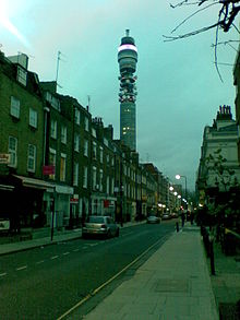
 A view of Cleveland Street looking south from the intersection with Greenwell Street (previously Buckingham Street), featuring the BT Tower | |
| Namesake | Charles FitzRoy, 2nd Duke of Cleveland |
|---|---|
| Length | 0.4 mi (0.64 km) |
| Postal code | W1 |
| Nearest Tube station | |
| Coordinates | 51°31′15″N 0°08′21″W / 51.520867°N 0.139196°W |
| north end | Euston Road |
| south end | Goodge Street |
Cleveland Street in central London runs north to south from Euston Road (A501) to the junction of Mortimer Street and Goodge Street. It lies within Fitzrovia, in the W1 post code area. Cleveland Street also runs along part of the border between Bloomsbury (ward) which is located in London Borough of Camden, and West End (ward) in the City of Westminster.[1] In the 17th century, the way was known as the Green Lane, when the area was still rural, or Wrastling Lane, after a nearby amphitheatre for boxing and wrestling.[2]
- ^ "Welcome to Westminster.gov.uk". Westminster.gov.uk. 27 May 2014. Archived from the original on 28 March 2012. Retrieved 28 March 2016.
- ^ "Marylebone and its Manors", Transactions of the London and Middlesex Archaeological Society, 4: 64, 1918
© MMXXIII Rich X Search. We shall prevail. All rights reserved. Rich X Search
