Back Aire métropolitaine de Cluj-Napoca French Kolozsvár metropolisztérség Hungarian Zona metropolitana di Cluj-Napoca Italian Metropoolregio Cluj-Napoca Dutch Zona metropolitană Cluj-Napoca Romanian
Cluj Metropolitan Area | |
|---|---|
Metropolitan area | |
 | |
| Coordinates: 46°46′N 23°35′E / 46.767°N 23.583°E | |
| Country | |
| County | Cluj County |
| Central Municipality | Cluj-Napoca |
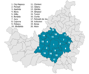
| Other localities | Aiton, Apahida, Baciu, Bonțida, Borșa, Căianu, Chinteni, Ciurila, Cojocna, Feleacu, Florești, Gârbău, Gilău, Jucu, Săvădisla, Sânpaul, Tureni, Vultureni |
| Functional | 2008 |
| Area | |
| • Total | 1,603 km2 (619 sq mi) |
| Population (2021 census)[1] | |
| • Total | 425,130 |
| • Density | 266/km2 (690/sq mi) |
| Time zone | UTC+2 (EET) |
| • Summer (DST) | UTC+3 (EEST) |
| Postal Code | 40wxyz1 |
| Area code | +40 x642 |
| Website | www |
| 1w, x, y, and z are digits that indicate the street, part of the street, or even the building of the address 2x is a digit indicating the operator: 2 for the former national operator, Romtelecom, and 3 for the other ground telephone networks | |
The Cluj metropolitan area is a metropolitan area in Cluj County, which includes Cluj-Napoca and 19 communes nearby: Aiton, Apahida, Baciu, Bonțida, Borșa, Căianu, Chinteni, Ciurila, Cojocna, Feleacu, Florești, Gilău, Gârbau, Jucu, Petreștii de Jos, Săvădisla, Sânpaul, Tureni, Vultureni.
The total area of the metropolitan area is 1,603 km2 (619 sq mi), which comprises 24% of the territory of Cluj County. According to the 2021 census, the population of the 20 administrative units totals 425,130 people, of whom 286,598 live in Cluj-Napoca.[1]
- ^ a b "Population at 2021 Census" (in Romanian). INSSE. 31 May 2023.
© MMXXIII Rich X Search. We shall prevail. All rights reserved. Rich X Search