Back Colegiales CEB Colegiales German Colegiales (Buenos Aires) Spanish Colegiales (Buenos Aires) Basque Colegiales French Colegiales Italian コレヒアレス Japanese Colegiales Latin Kolechjalesas Lithuanian Colegiales Malagasy
Colegiales | |
|---|---|
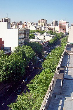
 Federico Lacroze Avenue | |
 Emblem[1] | |
 Location of Colegiales within Buenos Aires | |
| Country | Argentina |
| Autonomous City | Buenos Aires |
| Comuna | C13 |
| Area | |
| • Total | 2.3 km2 (0.9 sq mi) |
| Elevation | 25 m (82 ft) |
| Population (2001) | |
| • Total | 56,998 |
| • Density | 25,000/km2 (64,000/sq mi) |
| Time zone | UTC-3 (ART) |

Colegiales is a barrio or district in Buenos Aires, Argentina. It is located between Alvarez Thomas av., Forest av., De los Incas av., Virrey del Pino st., Cabildo av., Jorge Newbery st., Crámer st. and Dorrego av. This neighborhood offers a vast amount of contrast and opportunities.
There are large and tall buildings that go from the Crámer street to Avenida Cabildo and traditional houses up to three stories. This district has become a busy one with many pedestrians and cars on the streets. This neighborhood is mainly residential, with some non-residential areas like the classification yard in the north-east zone, the fairs in the south-west (where until the late 1960s there was another classification yard), and the UCA Colegiales campus in the south-east.
- ^ "The emblems of the 48 barrios of Buenos Aires were presented" (Spanish) by ámbito.com August 29, 2011
© MMXXIII Rich X Search. We shall prevail. All rights reserved. Rich X Search