Back Municipio de Colerain (condado de Lancaster) Spanish Colerain Township (comté de Lancaster, Pennsylvanie) French Коулрейн Тауншип (округ Ланкастер, Пенсільванія) Ukrainian Xã Colerain, Quận Lancaster, Pennsylvania Vietnamese
Colerain Township, Lancaster County, Pennsylvania | |
|---|---|
 Historic house in Andrews Bridge | |
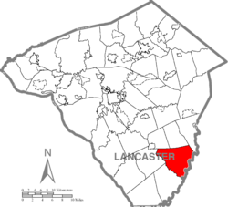
 Map of Lancaster County highlighting Colerain Township | |
| Country | United States |
| State | Pennsylvania |
| County | Lancaster |
| Settled | 1758 |
| Incorporated | 1738 |
| Government | |
| • Type | Board of Supervisors |
| Area | |
| • Total | 29.02 sq mi (75.16 km2) |
| • Land | 28.35 sq mi (73.43 km2) |
| • Water | 0.67 sq mi (1.73 km2) |
| Population (2020) | |
| • Total | 3,883 |
| • Estimate (2021)[2] | 3,913 |
| • Density | 130/sq mi (52/km2) |
| Time zone | UTC-5 (Eastern (EST)) |
| • Summer (DST) | UTC-4 (EDT) |
| Area code | 717 |
| FIPS code | 42-071-15056 |
| Website | coleraintwppa |
Colerain Township is a township in southeastern Lancaster County, Pennsylvania, United States. The population was 3,883 at the 2020 census,[3] an increase over the figure of 3,635 tabulated in 2010.[4] It is part of the Solanco School District.
Colerain Township was organized as a township in 1738. It was settled mainly by the Irish and was named after Coleraine, a seaport town in County Londonderry, now in Northern Ireland. Records show that Presbyterian Scots and Scotch-Irish also moved into Colerain Township very early into its settlement.
According to the 2020 "ACS 5-Year Estimates Data Profiles", 61.8% of the township's population spoke only English, while 38.1 spoke an "other [than Spanish] Indo-European language"[3] (basically Pennsylvania German/German).
- ^ "2016 U.S. Gazetteer Files". United States Census Bureau. Retrieved Aug 14, 2017.
- ^ Bureau, US Census. "City and Town Population Totals: 2020-2021". Census.gov. US Census Bureau. Retrieved 9 July 2022.
- ^ a b Cite error: The named reference
lastcensuswas invoked but never defined (see the help page). - ^ "U.S. Census website". United States Census Bureau. Retrieved 2017-02-26.
© MMXXIII Rich X Search. We shall prevail. All rights reserved. Rich X Search