Back مقاطعة كولز (إلينوي) Arabic کولز بؤلگهسی، ایلینوی AZB Coles County, Illinois BAR Колс (акруга) Byelorussian Коулс (окръг, Илинойс) Bulgarian কোলেস কাউন্টি, ইলিনয়স BPY Coles Gông (Illinois) CDO Коулс (гуо, Иллинойс) CE Coles County CEB Coles County, Illinois Welsh
Coles County | |
|---|---|
 | |
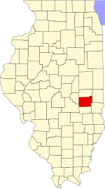
 Location within the U.S. state of Illinois | |
 Illinois's location within the U.S. | |
| Coordinates: 39°31′N 88°13′W / 39.51°N 88.22°W | |
| Country | |
| State | |
| Founded | December 25, 1830 |
| Named for | Edward Coles |
| Seat | Charleston |
| Largest city | Charleston |
| Area | |
| • Total | 510 sq mi (1,300 km2) |
| • Land | 508 sq mi (1,320 km2) |
| • Water | 1.8 sq mi (5 km2) 0.4% |
| Population (2020) | |
| • Total | 46,863 |
| • Density | 92/sq mi (35/km2) |
| Time zone | UTC−6 (Central) |
| • Summer (DST) | UTC−5 (CDT) |
| Congressional districts | 12th, 15th |
| Website | www |
Coles County is a county in Illinois. As of the 2020 census, the population was 46,863.[1] Its county seat is Charleston,[2] which is also the home of Eastern Illinois University.
Coles County is part of the Charleston–Mattoon, IL Micropolitan Statistical Area.
- ^ "State & County QuickFacts". United States Census Bureau. Archived from the original on June 6, 2011. Retrieved July 4, 2014.
- ^ "Find a County". National Association of Counties. Archived from the original on May 31, 2011. Retrieved June 7, 2011.
© MMXXIII Rich X Search. We shall prevail. All rights reserved. Rich X Search