Colorado Springs, CO Metropolitan Statistical Area | |
|---|---|
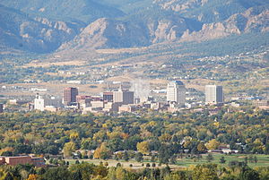
 Colorado Springs skyline with the Front Range in the background | |
 | |
| Country | |
| State | |
| Largest city | - Colorado Springs |
| Time zone | UTC−7 (MST) |
| • Summer (DST) | UTC−6 (MDT) |
The Colorado Springs, CO, Metropolitan Statistical Area is a United States Office of Management and Budget defined Metropolitan Statistical Area (MSA) located in the Colorado Springs region of the State of Colorado. The 2020 United States census counted a population of 755,105,[1] an increase of 17.0% since the 2010 United States Census. The Colorado Springs MSA is the 79th-most populous MSA in the United States.[2] The Colorado Springs MSA encompasses El Paso County and Teller County, Colorado. Approximately 88.40% percent of the MSA's population live in cities or CDPs. The Colorado Springs Metropolitan Statistical Area is the second-most populous component of the Front Range Urban Corridor.
| County | 2020 census | 2010 census | Change |
|---|---|---|---|
| El Paso County | 730,395 | 622,263 | +17.38% |
| Teller County | 24,710 | 23,350 | +5.82% |
| Total | 755,105 | 645,613 | +16.96% |
- ^ Star, Indianapolis. "Colorado Springs, CO Metro Area Demographics and Housing 2020 Decennial Census". Indianapolis Star. Retrieved 2022-01-27.
- ^ "Table 1. Annual Estimates of the Population of Metropolitan and Micropolitan Statistical Areas: April 1, 2010 to July 1, 2012 (CBSA-EST2012-01)" (CSV). 2012 Population Estimates. United States Census Bureau, Population Division. 2012-03-23. Retrieved 2013-11-05.
- ^ "Annual Estimates of the Resident Population for Counties of Colorado: April 1, 2010 to July 1, 2011". 2011 Population Estimates. United States Census Bureau, Population Division. April 2012. Archived from the original (CSV) on November 14, 2012. Retrieved April 18, 2012.
© MMXXIII Rich X Search. We shall prevail. All rights reserved. Rich X Search
