Back مقاطعة كولومبيا (واشنطن) Arabic Columbia County, Washington BAR Колумбия (окръг, Вашингтон) Bulgarian কলম্বিয়া কাউন্টি, ৱাশিংটন BPY Columbia Gông (Washington) CDO Колумбия (гуо, Вашингтон) CE Columbia County (kondado sa Tinipong Bansa, Washington) CEB Columbia County (Washington) Czech Columbia County, Washington Welsh Columbia County (Washington) German
Columbia County | |
|---|---|
 Columbia County Courthouse in Dayton | |
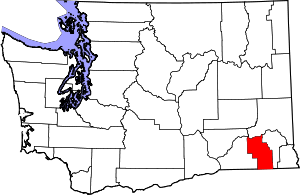
 Location within the U.S. state of Washington | |
 Washington's location within the U.S. | |
| Coordinates: 46°18′N 117°55′W / 46.3°N 117.92°W | |
| Country | |
| State | |
| Founded | November 11, 1875 |
| Named for | Columbia River |
| Seat | Dayton |
| Largest city | Dayton |
| Area | |
| • Total | 873 sq mi (2,260 km2) |
| • Land | 869 sq mi (2,250 km2) |
| • Water | 4.9 sq mi (13 km2) 0.6% |
| Population (2020) | |
| • Total | 3,952 |
| • Estimate (2022) | 4,026 |
| • Density | 4.6/sq mi (1.8/km2) |
| Time zone | UTC−8 (Pacific) |
| • Summer (DST) | UTC−7 (PDT) |
| Congressional district | 5th |
| Website | www |
Columbia County is a county located in the U.S. state of Washington. As of the 2020 census, the population was 3,952,[1] making it the second-least populous county in Washington. The county seat and largest city is Dayton. The county was created out of Walla Walla County on November 11, 1875,[2] and is named after the Columbia River (which does not flow through the county). Columbia County is included in the Walla Walla, WA Metropolitan Statistical Area.
- ^ "State & County QuickFacts". United States Census Bureau. Retrieved November 1, 2023.
- ^ "Milestones for Washington State History — Part 2: 1851 to 1900". HistoryLink.org. March 6, 2003.
© MMXXIII Rich X Search. We shall prevail. All rights reserved. Rich X Search
