| Conasauga River | |
|---|---|
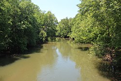
 View of the Conasauga River | |
 | |
| Physical characteristics | |
| Source | Cohutta Mountains |
| • coordinates | 34°51′57″N 84°35′32″W / 34.8657°N 84.5921°W |
| • elevation | ~ 2,400 feet (730 m)[1] |
| Mouth | Oostanaula River |
• location | Calhoun, GA |
• coordinates | 34°32′37″N 84°54′10″W / 34.5435°N 84.9027°W |
• elevation | ~ 620 feet (190 m)[2] |
| Length | 93 miles (150 km) |
| Basin size | 772 sq mi (2,000 km2) |
The Conasauga River is a river that runs through southeast Tennessee and northwest Georgia. The Conasauga River is 93 miles (150 km) long[3] and drains into the Oostanaula River, a tributary of the Coosa River and part of the watershed of the Gulf of Mexico. The river is home to over 90 species of fish and 25 surviving species of freshwater mussels.[4] Its watershed encompasses over 500,000 acres (2,000 km2) in two states, multiple counties, and two ecologically different regions.
- ^ U.S. Geological Survey. Dyer Gap quadrangle, GA. 1:24,000. 7.5 Minute Series. Washington D.C.: USGS, 1988.
- ^ U.S. Geological Survey. Calhoun North quadrangle, GA. 1:24,000. 7.5 Minute Series. Washington D.C.: USGS, 1982.
- ^ U.S. Geological Survey. National Hydrography Dataset high-resolution flowline data. The National Map Archived 2016-06-30 at the Wayback Machine, accessed April 27, 2011
- ^ "Conasauga River Watershed Ecosystem Restoration Project". Chattahoochee-Oconee National Forests. USDA Forest Service. Archived from the original on 5 February 2007.
© MMXXIII Rich X Search. We shall prevail. All rights reserved. Rich X Search
