| Cookridge | |
|---|---|
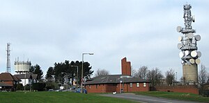
 High point on Otley Old Road, showing Tinshill Water Tower (left) Cookridge Fire Station (centre) and the Tinshill BT Tower (right) | |
Location within West Yorkshire | |
| Metropolitan borough | |
| Metropolitan county | |
| Region | |
| Country | England |
| Sovereign state | United Kingdom |
| Post town | LEEDS |
| Postcode district | LS16 |
| Dialling code | 0113 |
| Police | West Yorkshire |
| Fire | West Yorkshire |
| Ambulance | Yorkshire |
| UK Parliament | |


Cookridge is a suburb of north-west Leeds, West Yorkshire, England, north of the Leeds Outer Ring Road. In 1715 Ralph Thoresby described it as a village four miles from Leeds and three from Otley, dating from 1540.[1]
A mixture of suburban and council owned properties on the border with Holt Park and Tinshill, the area sits in both the Adel & Wharfedale ward of Leeds City Council and the Leeds North West parliamentary constituency. Before 2004, the area sat within Cookridge ward, named after the area.
Nearby places include Adel, Holt Park, Tinshill, Horsforth, Bramhope, Moor Grange and Ireland Wood.
Cookridge is one of the highest points in Leeds, with the elevation rising to 198 m (650 ft) above sea level close to the water tower on the eastern edge of the suburb.
Cookridge holds an annual scarecrow festival hosted by the Leeds Modernians.[2]
- ^ Ralph Thoresby (1715) Ducatus Leodiensis: or, the topography of the ancient and populous town and parish of Leedes, and parts adjacent in the West Riding of York, pages 157 to 163
- ^ "Cookridge Scarecrow Festival 2019 – North Leeds Mumbler | Your Local Parenting Community".
© MMXXIII Rich X Search. We shall prevail. All rights reserved. Rich X Search


